Places, Earth
Eastern Sierras to Reno and Western Nevada
Eastern Sierras to Reno and Western Nevada
|
|
Places, Earth
Eastern Sierras to Reno and Western Nevada |
|
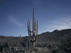
| We left Los Angeles two hours behind schedule, heading north on Highway 14 through Palmdale, Mojave and into that great basin between the Sierras and the mountains along the California-Nevada border. We drove through Red Rock Canyon, but were too far behind schedule to stop this time. Six weeks earlier, we turned east at California State Highway 178 to Ridgecrest and Death Valley, but this time, we charged north. A short time alter, Highway 14 Merged with US Highway 395 and we continued north. We stopped at the new Visitor Center in Lone Pine. The center had opened a week earlier and the helpful staff were still setting up. They suggested so many points of interest in the area, we immediately starting planning our next trip. We followed the suggestion to visit the Alabama Hills, a scenic area which has been the location for countless movies and television productions. The rocks looked almost as if they had been squeezed out, one atop another from a giant cake decorator. Although scenic, I think most people come for off-roading. | |
 This new Visitor Center had just opened. Photo date: 5-27-06. |
 Alabama Hills. |
| About twenty minutes later we pulled into Manzanar National Historic Site. Not much remains of the infamous Manzanar Relocation Camp, where mostly law-abiding US citizens of Japanese decent were detained during the confusing days of World War II. The site mostly contains some foundations, a few barracks exist in a section, and a driving trail with numbered signs and name signs explain what was once here. There is an obelisk in the cemetery and a new Interpretive Center. One other thing remained from those days, a high |
 Looking out from the Visitor Center. |
 Looking at the Cemetery with the Sierry Nevada Mountains beyond. |
 A guard Tower with the Sierry Nevada Mountains beyond. |
| wind with gusts to 35 MPH blew through the site making it difficult to even walk. We stayed in the car for the driving tour, taking photographs through the car window, opened just long enough for the photo because of blowing sand. We could only imagine how it must have been to have been forced to live for several years with this wind in this desolate location. | |
 The Courthouse in Independence. | A few miles north of Manzanar is the town of Independence. It looked as if it had been taken straight out of a book on classic American small towns. The court house looked like a movie set. About a block west of the highway/main street and down the street from the court house is the East California Museum. I was surprised to find so much museum in a small town. Two major indoor spaces held exhibits, a large outdoor exhibit area held hundreds of artifacts, and a natural plant garden extended from the other side of the parking lot. The museum is famous for |
| the "coyote dentures" which were home made by an inexperienced man using coyote teeth. A diorama built in the 1930 to express the importance of protecting mountain sheep fascinated me. The visitor is invited to throw the switch and the interior lights up and a rotating drum of text tells the story. What took a minute to notice was the little mechanical sheep bouncing through the background. We enjoyed wandering through the back yard which was filled with old buildings, farm equipment, mining equipment, earth moving equipment, equipment used by LA DWP in building the water aqueducts, and old vehicles. Most was rusted and filled with |
image here The Coyote Dentures may be one of the most popular exhibits at the East California Museum. |
| character. The native plant garden spanned a natural flowing stream which made a pleasant sounding environment. We had hoped to visit the Laws Railroad Museum just outside Bishop, but it had already closed for the day. The East California Museum made a wonderful substitute. | |
| We were behind schedule now and continued north on Highway 395 past the turn off to Devil's Postpile which I wanted to see, but wasn't yet open for the season. Also I am told to allow at least two hours because day visitors are required to take a shuttle. |
| We stopped for a few minutes at a roadside rest area near Mammoth Lakes. My wife had been asking to visit snow all winter, but the weather hadn't cooperated. Here she got her wish. We found a small patch of snow that she could touch and pose beside. I think it was the highlight of the trip for her. |
| We took a side trip at Mono Lake South Tufa. It was late, 37 degrees, and very windy. The trail from the parking lot to water's edge is only a few hundred feet, but with a headwind, it wasn't easy. About half way was a sign explaining about how Los Angeles Department of Water and Power has been mandated to reduce its use of water entering the lake and the water level is slowly rising. It is not expected to return to pre-DWP days, but the sign | |
| marked where the shore line will be when the mandated level of the lake has been achieved. So visit the South Tufa soon, if all goes well, these tufa will be two hundred feet off shore and under water in a few years. The wind was blowing toward shore at this point, and the edge of the lake was covered with natural soap suds due to the minerals in the water. The tufa are an unusual rock formation created when mineral springs bubbled up from the lake |
 South Tofu at Mono Lake. |
| floor and interacted with the lake water (when the water level was higher) , forming mineral deposits around the springs. Over time, these deposits accumulated making tall tubes. When water was diverted to Los Angeles and the lake level fell, they were exposed. I would have liked to have stayed till sunset, but it was just too darn cold. My wife lent me her gloves and returned to the car. I stayed a few minutes longer. | |
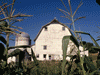
 Virginia Creek Settlement. | It was almost dark when a half hour later we reach our planned dinner stop at Virginia Creek Settlement. We planned this stop at a wonderful Italian restaurant in an unlikely location five miles south of Bridgeport because my brother-in-law's nephew owns it. But it was a wonderful dinner. It took five minutes to reach our motel, the Ruby Inn. We were glad our reservation were in order because the motel was otherwise full. It was a nice little place and the staff was helpful and friendly. |
| We got a late start. We had hoped to be in Bodie State Historic Park when it opened at 8:00, but it was already 8:30 when we reached the junction 7 miles south of Bridgeport. Then it took about a half hour to drive the 13 miles to Bodie, the last three on dirt. Here, in the closing days of May, there was still some snow on the ground. Any earlier in the season, you can expect snow, so don't bring your Hawaiian shirt and shorts or summer dress to Bodie in winter. We arrived at 9:00, which is also when the Visitor Center opens. Bodie was |
 A row of commercial buildings in Bodie. |
| a prosperous mining town which began after William (a.k.a. Waterman) S. Bodey discovered gold nearby in the 1859. There are several stories as to how the spelling changed from Bodey to Bodie, one saying there wasn't space on the sign for the bottom of the 'y'. The town which had a population of about 10,000 people by 1880, experienced a decline as the mines played out and a fire devastated the town in 1892. In 1932, another fire destroyed most of the town's business district. Today California State Parks maintains the town in a state of arrested decay, which means the remains are protected from damage from visitors, but except for a few buildings used for support, such as the visitor center, the site is left to decay naturally. | |
 One of several houses in Bodie, with a dusting of snow in late May. | There was light freshly fallen snow clinging to the shadows which added to the ambience. Bodie once had 65 saloons along with other business not mentioned in polite company. This gave rise to the story of a young girl who upon moving to Bodie said, "Goodbye God, I'm going to Bodie". We wandered the ruins for two and a half hours, which wasn't enough time, and then had to move on. The mill was established in 1861 with the first tour of the day starting at Noon. Unfortunately, we needed to be back in Bridgeport by Noon. We also missed the orientation film. When you plan |
| your visit, allow at least half a day. The town became a California State Historic Park in 1962. On the way out, we were slowed by a small traffic jamb at the gate. A car with a smashed front and a hole in the windshield on the passenger side was being attended by emergency vehicles. It was a chilling reminder to wear your seat belts at all times. | |
|
We attended church in Bridgeport in a small church with the snow capped mountains showing through the window behind the altar. We had fish and chips at Pop's Galley, owned by my brother-in-law's brother. I photographed the Court House, again straight out of an Americana movie, and we headed north on Highway 395. A few miles north of Topaz, we turned west onto State Highway 89. This was a |
 The Court House in Bridgeport. |
 River beside HIghway 89 in Alpine County. | beautiful drive through mountains, along mountain rivers, surrounded by trees, past more snow, around some tight curves over shear cliffs that my wife didn't care for, and finally reached Meyers, the gateway to Lake Tahoe. Lake Tahoe covers approximately 193 square miles, is 22 miles long and 12 miles wide. It is the eighth deepest lake in the world with its surface at 6,225 feet above sea level, maximum depth of 1,645 feet, and the floor is at 4,580 feet. |
| We then began a drive around three quarters of the lake's shore which measures about 71 miles (42 in California, 29 in Nevada). We stopped at an outlook over Emerald Bay State Park | |
 Emerald Bay and Fannette Island in Lake Tahoe. | and Fannette Island, the only island in the lake. The island has the remains of a tea house built in connection with Vikingsholm Castle, a Scandinavian style home built beginning in 1928 for Lora Josephine Knight. The house is open for tours beginning mid-June, but this was late May, so again this is more an account of what isn't yet open for the season in May. From here we continued north along the west side of the lake, passing numerous boat docks and small communities. There are several small museums around the lake, |
| but it was late and they had all closed for the day. We did stop for a few minutes in Tahoe City at Watson Cabin, part of North Lake Tahoe Historical Society. The museum was closed, but there is an easy trail to the lake shore and some outdoor folk art. | |
 Welcome to Nevada. |
A few minutes later, we were standing in the parking lot of a small store with the California/Nevada border sign at the edge. The store was closed so we were able to borrow the parking lot for a few minutes to pose beside the "Welcome to Nevada" sign. This was the most urban border crossing we would encounter on this trip. The drive south along the east side of the lake was just as beautiful and we stopped a few minutes at a rest stop with some wonderful views. Before long, we turned east on US Highway 50 and a few minutes later began a long downhill cost into Carson City, Nevada. Within minutes, we lost 1,500 feet in elevation and went from cool to hot. It was almost 8:00 pm, we found our motel, unpacked, and settled in for the evening. |
| We had more planned for today than time, so we got an early start, first stopping to photograph the new Nevada State Legislator office building and State Supreme Court building. The historic State Capital is on the north side of the Supreme Court, but we would visit it later today. | |
 The new Nevada State Legislator office building. |
 Nevada State Supreme Court building. |
| We wanted to "beat the crowds," so we headed east a short distance to State Route 341, the turnoff to Virginia City which first passes through a cluster of folk art and two other mining towns, Silver City | |
 A small display of folk art on the way to Virginia City. |
 Mine head tower in Silver City. |
| and Gold Hill. Virginia City is both a genuine historic town and a tourist trap. There are probably more small museums per block than anywhere I've seen before. Almost every other business has a small museum in the back, most charging a modest dollar or two. Two larger museums are "The Way it Was Museum" and the "Fourth Ward School". The Way it Was Museum is a collection of artifacts of the local history. While I'm not criticizing the museum, it is sad to think that similar museums all over the country don't receive the visitation and revenue of this institution. While the others are equally deserving, it is good to see that this type of collection is seen by the public here, if nowhere else. | |
 Main Street in Virginia City. |
 Mine exhibit at The Way it Was Museum. |
| The Fourth Ward School, built in 1876, is a wonderful look back at the history of Virginia City. Two of the four levels are open with hopes of opening another in the future. One classroom is set up at it looked a hundred years ago, others galleries include a printing office, mining equipment, an interesting diorama of the mine viewable through peep holes, historic news clippings, and out the windows, a view that extended for "a hundred miles ." We spent several hours walking the three main streets that run the length of Virginia City, but had to skip a ride on the |
 Fourth Ward School. |
| Virginia City, but had to skip a ride on the Virginia & Truckee Railroad for lack of time. We also saved the Chollar Mine tour for our next visit. My wife lost a few more coins in a slot machine at the famous Bucket of Blood and we started back a bit after 1:00, taking the truck route back for a different view. The car route had better scenery. | |
 Nevada State Railroad Museum. Nevada State Railroad Museum.Nevada State Railroad Museum. | Our next stop was to the Nevada State Railroad Museum back in Carson City. The main exhibit building houses two lines of track covered with rolling stock and smaller exhibits along the walls. Don't end your visit with the main building. I was at first disappointed until I learned of the other building and exhibits outside. The shed has many more pieces of rolling stock, many undergoing restoration. A turn-table connects the sections of track, one of which is used by the train that gives rides around the facility. |
| A mile or two north is the Nevada State Museum, a collection of natural and human history, art, and in what must be most of the basement, a full size diorama of a mine which exits to the outside. The museum buildings consist of the old historic wing facing the street with an attached section behind of modern construction. This building houses most of the exhibits and a matching wing across a plaza contains Native American exhibits and the gift shop. As a volunteer at "The Tar Pits Museum," the skeleton of a mammoth did peak my |
 Nevada State Museum is filled with wonderful exhibits. |
| interest. Further exhibits included a hall in the look of a western town, guns, mining, local history, contemporary art. One word of warning, the passage from the entrance lobby to most of the museum was not obvious and I needed to ask directions - I almost missed most of the museum. | |
| It was now late afternoon and we considered ourselves lucky to have been able to tour the Nevada State Capitol this Memorial Day. The historic Nevada State Capitol building is as wonderful as we expected. The main offices of the legislators have moved two doors south to the new building which we saw earlier that morning, but many state offices remain in this building. One of the old legislation chambers now houses a museum. It was now closing time and we had one last stop for the day. |
 Nevada State Capital. |
| My wife had told everyone that we were going to Reno, so now we embarked on our two hour trip to Reno. It was only about a half hour drive before we entered the city from the south. Not having a plan, we stopped at the first casino we found, The Atlantis, a brand new huge complex connected to the parking lot across the street with a pedestrian bridge containing dining facilities, slot machines, and more. My sheltered wife had never seen a large Nevada casino before and we wandered some time before finding the gift shop. While she shopped, I explored further to find an |
 Reno Arch. |
 Atlantis Casino. |
 Atmospherium Planetarium. |
|
artificial wave feature, more slots, more dining, glass elevators, everything you would expect to see in a palace of entertainment. We continued on into town and drove past several more historic building, all closed for the day, and casinos, never close. We drove past the University of Nevada-Reno campus and stopped briefly at the Fleischmann Atmospherium Planetarium. This "atmospherium" was built in 1963 as the first of its kind in the world to not only simulate a night sky, but also a day sky with weather. It too was closed and we returned to our second and last night in Carson City. | |
| We had one last stop before returning to our motel. It was dusk when we found the Governor's Mansion and took a few photos in the dimming light. |
| We left Carson City early the next morning, first stopping to see the Governor's Mansion in morning light. I wanted to see Nevada, so I chose the longer route home, through a large part of western Nevada. We traveled east on US Route 50 for about an hour before turning south onto US Route 95 at Fallon. We would spend the next nine hours driving south on this ribbon of asphalt through many small towns and empty landscape. |
|
part of western Nevada. We traveled east on US Route 50 for about an hour before turning south onto US Route 95 at Fallon. We would spend the next nine hours driving south on this ribbon of asphalt through many small towns and empty landscape. I love photographing old buildings and found many worthy subjects along Highway 95, either abandoned old buildings, or old buildings still in use. I photographed some wonderful weathered |
 Abandoned building in Schurz. |
|
buildings in Schurz, Hawthorne, Mina, Tonopah, Goldfield, and Beatty. We continued south about two hours until suddenly in the middle of the desert, we came upon Walker Lake, just north of Hawthorne. Walker Lake is a natural lake which has dropped over 130 feet in the last hundred years, resulting in various environmental issues. Still, it remains a significant recreational resource in the region.  Walker Lake. |
| A few minutes past Walker Lake I noticed ahead and off to the side, rows upon rows of identical simple buildings stretching out across the desert. I learned that Hawthorne, Nevada is home to the worlds largest ammunition dump and military storage facility which opened in1930. As we entered the town, the first thing I noticed was an area filled with red, white, and blue bomb casings standing vertically out of the sand, tails up, and a parade float with a model submarine proudly proclaiming, "Hawthorne, the World's |
 Hawthorne Army Depot. |
 Welcome to Hawthorne.
| Biggest Ammunition Dump." The next thing I noticed was a rest stop with large flower pin-wheels, again made of bomb casings. I guess with the worlds largest ammo dump next door, you get first choice of decommissioned military hardware from which to make metal sculptures. The third thing I noticed was The Mineral County Museum, another of those wonderful small town historical society museums. My wife later confessed that she was hoping I wouldn't notice the museum. Of most interest to me were the mysterious Spanish bells found buried nearby. Although |
| the Spanish explored Nevada, there is no record of Spanish Missions being established in the area, so the purpose and source of the bells remains a mystery. Continuing south were still more storage buildings and ammo bunkers alongside the road. | |
 Hawthorne Rest Area. |
 Mineral County Museum. |
 Boat House or House Boat? Not sure what this is beside Highway 95 in Mina, Nevada. |
The highway was now traveling in a general southeast direction as we passed through Mina. In a bit of whimsy, along side the road was a house boat. At least I think that's what it was. What looked like a boat on dry land was sitting there with a front door in the side and a more normal building behind. |
 Tonopah, Nevada. time to visit a small part of Tonopah Historic Mining Park, high on the hill above the city, which was the first one I came upon. We just didn't have the time to stop at the Central Nevada Museum which looks like it would have been just as worthy a stop. Another half hour and we came upon Goldfield, another historic town filled |
We had been traveling for some time in Esmeralda County but now crossed into Nye County for just a bit. The town of Tonopah, sometimes spelled Tonapah, lies along a stretch of the highway that dips into Nye County before returning to Esmeralda County. Tonopah is an old mining town with two museums. Unfortunately, I only had  Tonopah Historic Mining Park in Tonopah, Nevada. |
| with old historic buildings. I was saddened to see the state of Goldfield High School, built in 1907. This once beautiful building is now deteriorating and in danger of collapse. The owners lack the excessive funds required to repair this once grand building. Goldfield was born in the gold and silver boom of 1902. The town hangs on, a shadow if its more prosperous past. Nevada, the West, and for that matter, the world is full of these historic deteriorating ruins of once important structures. |
 A bit of Folk Art in Goldfield. |
| We journeyed through Scotty's Junction, literally a very wide spot in the road, and not much else. I'm not sure why there is such a large field of asphalt at this back way into Death Valley. We passed the lonely looking abandoned gas station that I had photographed a few weeks earlier during our Death Valley trip and on into Beatty. When we came this way in April, the Beatty Museum was closed, although the hours indicated that it should have been open. Well, this time it was still closed. Disappointed, we pushed on. |
 The Betty Museum was still closed. |
 Welcome to Nevada, but we were leaving at this point. . | Beatty is another entry portal to Death Valley and a few miles west is Ryolite Ghost Town, which we visited last month. Today we continue south along Highway 95. We left Highway 95 an hour later, taking Nevada State Highway 373 back into California. Unlike the crossing into Nevada two days earlier in an urban setting, this was now the middle of the desert with only the distant Longstreet Casino to remind us that we were leaving Nevada. We posed by this sign too, and headed toward Death Valley Junction. |
| Death Valley Junction was a mix of old deteriorating buildings (but remember, I like these old buildings) and a restored large U-shaped hotel building with one end capped by the Amargosa Opera House. The building was originally built in 1923 - 1925 by the Pacific Coast Borax Company as a company town. The Opera House was then a multi-purpose | |
 Amargosa Opera House | space named the Corkhill Hall. In 1968, Marta Becket began the long process of transforming the hall into the Amergosa Opera House and painted audience and characters on the walls and then cherubs on the ceiling. Eventually the town was bought by the Trust for Public Land and still delights visitors tothe desert with opera. It was now getting quite late, it was dinner time, and everything was closing, so we pounded south on California State Highway 127 another hour and a half. |
| We crossed the junction with California State Highway 178, the southern most portal to DeathValley and were now driving the same route home that we had taken a few weeks earlier, returning from Death Valley. It had taken longer to get here than I had expected and it was now certain that I was going to miss my ceramics class that evening. We pushed on to Baker and caught I-15 west, through Barstow, Boron, and Mojave. We were now back on Highway 14 south and arrived home just before 11:00 pm. |
| We were gone four days and three nights, drove 1,400 miles through two states, visited many sites, museums, historic sites, towns and cities, and saw many natural and artificial wonders. The biggest lesson I learned was to allow plenty of time and don't plan too much. My preliminary research didn't show very much in the way of historic sites and museums in the eastern Sierras,but as we traveled, we found more than we had time to see. There are many small town museumsthat don't attract notice in the guide book. Serendipity yields far more points of interest. We arrived home with enough plans to retrace our path several more times to see all that we missed. |

|

|

|
| Note:This is not the official site for any of the places shown in Places Earth. Places Earth is not responsible for accuracy of the information. Hours of operations, prices, exhibits, and sometimes locations are subject to change without notice. |
|
Support this Web Site I hope that you find this web site helpful. It started because of my love for Architecture and interest in History and a desire to share my photographs and tales of my adventures. I don't allow paid advertising. This web site is for your benefit and enjoyment and I make no profit on it. For twenty years it has been supported primarily from my regular paycheck as a Set Designer. If you are in the need of a designer, please see my Set Designer portfolio site Set Design Portfolio. |
|
Links |

|
This site maintained by Kenneth A. Larson. Copyright © 2004 - 2023, Kenneth A. Larson. All Rights Reserved. Website content including photographic and graphic images may not be redistributed for use on another website. |

|

|

|