Places, Earth
Eastern Sierras, 2009
Eastern Sierras, 2009
|
|
Places, Earth
Eastern Sierras, 2009 |
|
| We usually plan to leave about 7:00 and end up leaving at 8:00, so today we decided to leave at 8:00 and got off at 8:30. We had traveled this route the year before and were attempting to tie up some more loose ends. It was a six hour drive to our destination and it only took us nine hours, with stops along the way. |

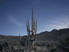
| We headed north on Highway 14 and then Highway 395. Just north of Mojave I noticed several moth balled passenger aircraft at the Mojave Airport. I've seen them before, but with the current economic situation, there just seemed a lot more surplus aircraft parked here in the dry dessert, just like the surplus military aircraft we saw two months ago in Tucson. Our first major stop was Fossil Falls, a little north of Little Lake. A mile or so of well maintained dirt road brought us to the parking area followed by a .21 mile easy hike to the spot where many years ago, hot flowing lava cooled into bazaar shapes. Highway 395 is lined with volcanic rock for a distance near here making it easier to find Fossil Falls. To get here, turn east at Cinder Road. |

| We continued north to Cottonwood Charcoal Kilns, also a few miles off Highway 395 along another well maintained dirt road. The year before, we had visited ten well preserved Wildrose charcoal kilns in Death Valley National Park. The kilns we visited today were just two and not so well preserved, but a lot closer to the highway. Colonel Sherman Stevens built a sawmill and flume on Cottonwood Creek in the Sierras to the west and these charcoal kilns near the west shore of Owens Lake, which then had water. Lumber was used in the mine and wood for heating was converted into charcoal in these kilns. The lumber and charcoal was transported in boats to the east shore where the mines were located. I photographed the kilns and we continued north. Watch closely for the sign along the west shore of Owens Lake. |

| We stopped at the Lone Pine Visitor Center and continued to Manzanar Historic Site. We had visited this Japanese interment camp three years earlier and I was hoping the reconstructed barracks would be open. Unfortunately, we were told they are still not ready and to try again next year. We drove the auto tour path and continued north. |
 Carson and Colorado Railway Line locomotive at Dehy Park in Independence. In the town of Independence, we stopped a few minutes at Dehy Park where a donated Southern Pacific locomotive from the Carson and Colorado Railway Line is displayed. We continued north past Crowley Lake to Mammoth Lakes Visitor Center and got more information for tomorrow. We arrived at the Ski Museum about a half hour before closing, but to our disappointment, it was already closed. Onward to the north we traveled past June Lake and into our destination of Lee Vining. |
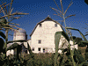
 Schoolhouse Museum. The Upside Down House is in the distance. We checked into our motel, the Lake View Lodge, and drove the short distance to Schoolhouse Museum. There are several large and medium size pieces of mining equipment displayed around the site but possibly the featured attraction is the Upside Down House. This building was built upside down to the amusement of former silent film actress Nellie Bly O'Bryan who fell in love with this area of the Eastern Sierras. The School House is filled with exhibits on local history. The school house and the Upside Down House had both been moved to this site from further north but now make a nice little museum complex a block off Highway 395 at First and Main. If coming from the south, turn right immediately after the Shell gas station. |
We got our first tank of gas for the trip and then enjoyed a nice dinner at Nicely's. We stopped at the Mono Lake Committee building on Highway 395 and headed back south to South Tufa. We arrived a little before sunset and marveled at these natural stone sculptures in the fading light. The tufa were formed when mineral filled spring water reacted with Mono Lake salt water to form these originally underwater towers. As the lake level changes, the tufa are exposed and resubmerge. We returned to our room and settled off to sleep.  South Tufa at Mono Lake. |
| Day Two |
| We awoke, got ready, and headed to the hotel's café for breakfast. The continental breakfast was a little thin and wasn't included, so we walked back to Nicely's for a satisfying breakfast. |
 The lake view from Lake View Lodge. |
 Tramway at Mammoth Lakes. We arrived at Mammoth Lakes about 9:00 and bought our tickets for the Red Meadow Shuttle. As we waited in line, the group ahead of us was assigned to bus 5, but since there was just two of us, we got the last spaces on bus 4. We only waited about 20 minutes for the bus and headed into the valley and our first stop at Devil's Postpile National Monument. The monument is small and within Inyo National Forest and the two agencies joint manage this recreational resource. The area is also the Ansel Adams Wilderness and lies in the easern edge of Madera County. The entire area is seismically active and a dormant volcano. About 800,000 years ago, the Long Valley Caldera was formed in one of the largest volcanic explosions know to geologists. So don't delay visiting this wonderful scenic masterpiece, you never know when it will be blown away. |
 Looking up at the basalt columns of Devil's Postpile. We walked the easy hike to Devils Postpile and marveled from below. While my wife waited below, I hiked the loop to the top. As I stood on the top, I took a photo of my wife far below and she photographed me from below, but you have to take my word for it, she messed up on the photo. |
| We walked back to the Ranger Sation and then I left my wife resting in the shade as I walked half way back to the Postpile and then took the side trail, that I had partially walked earlier to see the river, and continued about one and a half miles, mostly uphill, to Minaret Falls. About half way there was a small fall and a family was debating if this was it and if they should continue, but I continued on and eventually found the falls. It was worth the trip. The fall is not a vertical drop like many other falls, but rather the water cascaded down the slopping cliff, dividing and merging, bouncing off rocks, and flowing along the rock face. The return was mostly downhill and my wife was glad for my return as she was getting bored. |
| We took the shuttle to Red Meadow Resort where we bought a bottle of water and began the 1.2 mile trail to Rainbow Falls. About half of the hike was through an area slowly recovering from a forest fire many years ago. Eventually we reached the fall and it was beautiful and there was a rainbow. We stayed a while and headed back. It was mostly up hill and I was not happy to discovering when we reached the trail head that I had dropped my favorite sweater along the return. So I left my heavy camera gear with my wife and ran back to the fall but did not find the sweater. As I trudged back to the trail head the second time, a woman asked if I had fond what I obviously was looking for and I said no, I was still looking for my sweater. She said, she left it on a log a short distance ahead and there it was, about half way back. |
| I was pretty worn out by the time we boarded the shuttle for the return. We had hoped to ride the aerial tramway but it was about to close for the day. We had our lunch about 5:00 and made one last stop. Just at the point of the road where private cars are restricted, there is a turn off to Minaret Vistas with a breathtaking view of the valley we had just left. My wife got a view of Minaret Falls - from about five miles away - a white smudge against the green. We enjoyed the view and headed back to Lee Vining. We enjoyed a wonderful dinner at Bodie Mikes and returned to our room. We were exhausted and tried to fall asleep amid the sound of fireworks. |
| Day Three |
| We left an early wake-up call, enjoyed breakfast at Nicely's, and were at South Tufa about 7:30. We had never been there so early. It was less populated with tourists, less windy, quieter, and the water was almost mirror-like. We spent about an hour wandering the site and photographing these unusual natural towers. |
| We returned to our room and checked out, then visited the Mono Basin National Forest Scenic Area Visitor Center (opened in 1992). I got more information to plan our last few hours in this scenic wonderland. Our visit to Lee Vining ended with Mass at Our Savior of the Mountains, a nice little church at the foot of the Sierras. |
| We then headed to Panum Crater a little south of the lake. Panum Crater is the youngest volcano on Earth at only 600 years. The site consists of a cinder cone forming a ring around the plug that formed in a later phase over several separate events. There are two trails, the Rim Trail and The Plug Trail. I walked maybe 1/6 of the way around the rim, but I don't think it formed a loop since I never saw a trail going the other way from the junction. I only walked a short part of the Plug trail, maybe the two trails meet on the other side, I'm not sure. I spent about an hour, but would have needed two or three to have completed both hikes. Panum is the northern most volcano cone of a chain of 21 extending south from the lake that forms the youngest mountain range in North America, up to 35,000 years. It was an interesting way to wrap up my trip to Mono Lake. |
| From here we got back on Highway 395 and retraced our path back to Los Angeles only stopping at rest stops as needed - including a 30 minute nap at one. We arrived home about 6:30 after getting our second tank of gas for the trip at a local station. Two of our cats met us at the door, the third always forgets us until I give her a reminder hug. Although we could make another trip or two to the area, we did wrap up a loose end from two previous trips (2006 and 2008) and learned more about this scenic and historic section of California. |

|

|

|
| Note:This is not the official site for any of the places shown in Places Earth. Places Earth is not responsible for accuracy of the information. Hours of operations, prices, exhibits, and sometimes locations are subject to change without notice. |
|
Support this Web Site I hope that you find this web site helpful. It started because of my love for Architecture and interest in History and a desire to share my photographs and tales of my adventures. I don't allow paid advertising. This web site is for your benefit and enjoyment and I make no profit on it. For twenty years it has been supported primarily from my regular paycheck as a Set Designer. If you are in the need of a designer, please see my Set Designer portfolio site Set Design Portfolio. |
|
Links |

|
This site maintained by Kenneth A. Larson. Copyright © 2004 - 2023, Kenneth A. Larson. All Rights Reserved. Website content including photographic and graphic images may not be redistributed for use on another website. |

|

|

|