Places, Earth
Holiday in Hawaii
Holiday in Hawaii
|
|
Places, Earth
Holiday in Hawaii |
|
| Day One - Gettin' There |
|
We arrived at Los Angeles International Airport early and before long were sitting in the terminal waiting for our flight. The American Airlines 757 took off on time and within minutes we watched the west coast of North American disappear behind us. I was operating on only two hours sleep so I slept the first third of the way. There were some rough spots but eventually it
smoothed out and I watched the pattern of the shadows of the clouds on the ocean below. Finally the airplane began its decent and we landed at Kahului on the Island of Maui in the State of
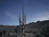
Hawaii after the 5 1/2 hour flight. Maui is nicknamed The Valley Isle because it currently consists of two volcanos with a lowland between. A million years ago, what is now Maui was a much larger island that included what we now know as Molokai, Lanai, and Kohoolawe. By about 150,000 years ago, erosion and sea level change had dissolved the intervening land making these four separate, but closely adjoining, islands. |
 East coast of Maui - the flight is almost over. | |
| In perhaps a few tens of thousands of years, Maui will be two islands, west and east and the valley, where most people currently life, will be gone. The entire Hawaiian archipelago is formed by a stationary hotspot with the Earth's crust slowly moving northwest leaving a trail of extinct volcanos behind to mark the location. Many of these older volcanos are now sea mounts, or underwater mountains, and the leading edge of the Big Island is still growing as new lava enters the sea. A few miles further on, Loihi, a new underwater volcano, is slowly growing to the surface. A few million years from now, all of the Hawaiian Islands we know today will be underwater sea mounts and new islands will string out to the southeast. | ||
| The Island of Maui is 729 square miles with 120 miles of coastline, most of it spectacular. The island is 48 miles long and 26 miles wide and the highest point, which we would visit in two days, is 10,023 feet with a road to the top. |
| We retrieved our bags, rented the car, and found our Hotel right on the water. We unloaded and my wife's friend's husband came to lead us to their house for diner and conversation. A year ago I got sick on the second day of a ten-day trip to Texas, this year I did one better by first noticing I had a cold as the plane descended and my ears wouldn't clear. We returned to our room and settled off to sleep, tired from the two hour time change. |
| Day Two- The Road To Hana |
| Because of the two hour time difference, we awoke early. The cold that started yesterday was worse which also contributed to my poor sleep. We tried to make the best of it but the day didn't go well. After breakfast, we headed east along the Hana Highway. |
| The Road to Hana is something you have to do once, more if you don't mind the road itself. The road is long, slow, and with many narrow one-lane sections and close to 60 one-lane bridges requiring cars in one direction to wait for cars from the opposite to pass. This works better in the morning when most people are going the same way. While the road is not a superhighway and Hana is more just a place to turn around, the scenery along the way is beautiful and the road is lined with numerous gardens, parks, natural wonders, and venders. When if |
 One of the 60 narrow bridges. | |
| comes to the Road to Hana, it's the journey that is the reason for going. | ||
| Our first stop was Hookipa Point just past the town of Lower Paia along Hana Road with some spectacular views west along the north shore and waves crashed against rocks. This beach is renowned for it's excellent wind surfing, considered by some to be the best in the world. I had a short conversation with Bud the Bird Man who stood there with four brightly colored macaws prepared to pose for photos. Bud runs a 1,000 acre reserve for these long-lived animals, some of whom, along with Bud, have been in movies and TV. We had a long road ahead so off we went. |
 Hookipa Point. |
| We continued along enjoying the scenery, sometimes stopping, sometimes not. We wanted to stop at one waterfall, but all the limited parking was taken. We passed Garden of Eden Botanical Garden (entrance easy to see from Hana Road) and thought if we had time we would stop on the way back but didn't. We stopped a few minutes at Kaumahina State Way Station, one of several rest areas along the road, with coastline views and hiking trails. This is where we saw our first wild chickens that roam the island. We got back in the car and continued on. |
| We stopped a few minutes at Halfway to Hana, at mile marker 17, where my wife got a mango shaved ice and I looked at the mounted boar heads. We had planned to stop for their famous banana bread on the way back but didn't have time for that either. I turned off on Ula'ino Road attempting to visit Kahanu Gardens but it was closed. On the way back Hana Road I wanted to visit Hana Lave Tube, a privately owned lava tube, but my wife had reluctantly entered two in California the month before and didn't want to go in another. Across the road, Blue Pool was also closed. |
| We continued to Waianapanapa State Park with its black sand beach, blow hole, lava tube, cemeteries, natural arch, caves, and trails. First we saw one cemetery from a distance, then walked down to the beach, stopping to take pictures along the way of waves crashing against the jagged rocks and viewing the natural arch from a distance. This was the first time my wife had seen a black sand beach, but she declined posing. I took a number of photographs of waves crashing against rocks or black sand while dodging the waves since I never dress properly for the beach. |
 Waianapanapa State Park | |
| We wandered a bit trying to find the lave tube but couldn't and my wife wanted to go back to the car so we passed on the caves. Still it was a nice stop and would have been better had we have more time. The turn off to the park is just a mile or two before Hana and easy to find. | ||
| We continued the short distance to Hana and then continued. I saw a sign for Arc Pottery and being an ammeter ceramist, I wanted to stop on the way back but ran out of time. We stopped at Wailua Fall where we watched a craftsman making palm woven hats and baskets (for sale) on a bench, and then continued. We drove through a finger of Haleakala National Park and then reached the end of our drive at Kipahulu and the grave of the famous aviator Charles A. Lindbergh. The grave has only a small marker, he faces the Big Island, the cemetery is small and overlooks the sea, and there is a small church. A simple resting place for a simple man with complex dreams. |
 Grave of Charles A. Lindbergh. |
| Hana Road ends a few miles further on and there is an unpaved stretch for a few miles before becoming Pi'ilani Road and continuing back to Kahului. Either way was a long way back so we returned the way we came. This time we stopped at Haleakala National Park, Kipahulu Visitor Center, showed our annual pass, and parked. We walked the quarter mile to the Seven Sacred Pools where people were lining up to dive in. We passed on getting wet and returned to the car and continued our drive home. Had we had more time, a short hike would have taken us to two waterfalls upstream. |
 Seven Sacred Pools |
| It had taken us six and a half hours to get this far so we decided we didn't have time to stop any more and headed back. Then things took a turn for the not so good. Just as I was crossing one of those narrow bridges, a sudden ray of late afternoon sunlight through the trees created glare on the windshield just as should have seen the guard rail extended further than I thought and I scraped the side of the rental car. This is something you don't want to do and I lost interest in the rest of the trip. I wasn't being careless, I just had the bad luck of picking up glare just as I needed to see. The bridge was fine, no one hurt, and only minor damage to the car. We finally made it back after another stop at Hookipa Point where hundreds of people awaited the sunset. We had plans to meet my wife's friends for dinner so we continued before the sun set. |
| We had a pleasant dinner with our friends at Queen Kaahumani Center on Ka'ahumanu Avenue in Kahului. This is the biggest mall on Maui with some historic displays to Queen Kaahumani. We said goodnight to our friends and settled off to another uneasy sleep. |
| Day Three - Volcano. |
| We awoke about 2 am local time and were up most of the rest of the night. My wife went to church in Kihei with her friends and I attended Mass a few blocks from our hotel. My service was over before my wife got back, so I drove around town a little and photographed a few points of interest and old buildings. |
| About 11:00, my wife and her friends picked me up and we headed to Haleakala National Park along Haleakala Highway (Highway 37) which becomes Kula Highway stopping first at Holy Ghost Church just to see it. Holy Ghost Mission is an octagon shaped church overlooking the sea. The address is 4300 Lower Kula Road in Waiakoa. My wife's friend's husband, Alex, is Hawaiian so I didn't need my National Parks Annual card since Hawaiians are admitted free since the mountain is a holy place to them. Touring Upcountry, as the slopes of the volcano are referred to as, with someone who knows the culture made the trip more interesting and rewarding. |
 Front of Holy Ghost Mission. |
| The road up is steep and winding and we passed through the clouds as we climbed. First we went to the very top of the volcanic mountain to an elevation of 10,023 feet. Below us was not a caldera, the hole left after a volcano explodes. Hawaiian volcanos don't explode. The lava is non-viscus enough to not trap a lot of gas which is what usually causes explosions. The crater here was simply created by ordinary erosion which has since been partly filled in by later volcanic action. The Last eruption occurred a recent 200 years ago. It was an unearthly but beautiful sight looking down |
 The Valley at the top of Haleakala. | |
| this valley in multi-colored earth tones. There is a long trail into the center of the valley, but that is an all-day hike. On top of another peak a few hundred feet west were a number of small to medium size observatories for both the University of Hawaii and military agencies. Way of to the south we could see three mountain peaks of the Big Island, the closest large peak is Mauna Kea and the other large peak is Mauna Loa, Mauna Kea has several world-class observatories at its summit. | ||
| We headed the short distance to the upper Visitor Center which provided a different angle view of the valley below. Below were many small cinder cones of various shades of reds, brown, and tans. We continued down slop to another observation point, this time around a corner from the previous. |
| We started down on a slope so steep that Alex constantly pulled over to cool the breaks which were smoking each time. Eventually we made it to the lower Visitor Center where we let the breaks cool again while we looked around and took more photos. One last stop was at Hosmer Campgrounds with an interpretive trail through both native and imported plants and a viewing stop for birds. |
| We continued down with the breaks still hot and my ear hurting as my cold prevented me from adjusting to the altitude change. We stopped a while at Kula Lodge with a restaurant in a lovely setting, a market, and Curtis Wilson Coast Gallery selling beautiful island art. Kula Lodge is on Haleakala Highway - State Highway 377 a little south of Haleakala Crater Road. I had hoped to have time for Kula Botanical Gardens, also along Highway 377, but it was getting late. We tried to stop at Alii Gardens, a lavender farm overlooking the ocean, but it was closed as it was getting late. This garden is on Waipoli Road near the junction of Highways 37 and 377. Before continuing we did watch for a few minutes as powered hang gliders flew overhead. Further on is Maui's Winery at 'Ulupalakua Ranch, but it was much too late to go further. We finally made it back to Kahului for dinner and a final visit with friends. |
| I had asked Alex about the counties in Hawaii since that is how I usually organize my photos. He explained that the Big Island, Oahu, and Kauai are each their own counties, but Maui County includes Molokai, Lanai, and Kahoolawe. You don't hear much about Kahoolawe. It was used for bombing practice during World War II and is only now being cleared. It is largely unvisited and shouldn't be unless you get clearance first, and don't use a cell phone as it might set off undiscovered explosives. Also Alex explained the Hawaiian language which has about 10 fewer letters than English and heavily uses some letters that was less used in English. Also this smaller number of letters results in the many words that repeat sections to increase the number of words from fewer letters, such as King Kamehameha. |
| We returned to our room and got ready to check out tomorrow, then took a last look at the brightly lit cruise ship that had been in the harbor the last two days and drifted off to sleep. |
| Day Four - The Island Hop |
| I awoke early again and my ear still hadn't returned to normal from yesterday. We started packing for our flight to Oahu and I considered seeing a doctor. I had noticed a Kaiser medical building the day before and hoped to see a doctor but when I pulled up at 6:00 AM, it turned out to be only a clinic and wouldn't open till 8:00 so I returned to the hotel and waited for breakfast at 7:00. After breakfast, I drove back to Kaiser and everyone was so helpful and understanding to squeeze me in without an appointment and I was back at the hotel with medication for an ear infection sooner than I expected. |
| We packed and checked out and I let my wife shop at the Queen Kaahumani Center for a few last minute Maui souvenirs. |
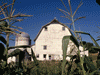
| Next we headed for the Alexander and Baldwin Sugar Museum which is housed in a former superintendent's house with indoor and outdoor exhibits on the sugar industry which is currently the largest agricultural industry in Hawaii. Six rooms divide the story into subjects: geography, water, human resources, plantation life, field work, and the mill. We took our time on this smallish but interesting museum across the street from the actual mill. The mill and museum is in he middle of cane fields along Hansen Road a little west of Mokulele Highway in Pu'unene. |
 Alexander and Baldwin Sugar Museum |
| Mokulele Highway heads south to the southwest coast and Kihei - a large part of the island we didn't get to. We also never made it west to Lahaina which is a popular and historic part of West Maui. We will just need to plan more time for the next visit. |
| We now headed for the airport but made one last quick stop at Kanaha Pond State Wildlife Sanctuary. Once a royal fishpond, it now protects two endangered Hawaiian species, the stilt and the coot. The observation point is off the very west end of Haleakala Highway between Hana Road and Dairy Road. |
| As expected, it took a little time to check in our damaged rental car but the people were understanding and the woman at the insurance company wanted to personally inspect the vehicle - in Hawaii. We worked our way through and finally sat down and awaited our flight. |
| The flight from Maui to Oahu is short, but you can't drive. The plane started east and made a U-turn and headed west passing west Maui for a few minutes with the Big Island beyond. Then within minutes we were even with the east end of Molokai and a few minutes more, we had passed the west end. I almost laughed when we hit maximum altitude and for the first time in 24 hours, my ear felt fine - for a few minutes before we began our decent. The plane never made it to cruising altitude before in began its descent to Oahu. My ear actually felt better when we landed than before we took off only about 40 minutes earlier. We found our rental car and took less than five minutes to reach our hotel overlooking the airport. The view from the seventh floor corner room actually wasn't great, just a service area of the airport, but the room was nice, central to everything we planned to do, and we unpacked, ate, and settled in. As I unpacked the checked bag, I noticed things had moved around and then a notice that the Transportation Security Administration had randomly hand inspected our bag. I wouldn't mind except things that I had carefully packed to not be damaged were. |
| Day Five - The Seat of Government |
| We slept better but still awoke before the wake-up call. We got an early start, but not early enough. We had planned to visit the Arizona Memorial and related sites and were told to come early, but only 45 minutes after opening, the tickets were already sold out till early afternoon. Also I wasn't allowed to bring in my camera bags without which I couldn't do the photography I wanted, so this had to be rethought. |
| So we drove into town and after much difficulty found a parking lot. Almost all the parking in the area was meter or self serve and I didn't have change or small bills. I finally found a lot in China Town with an attendant. It was only about three blocks to the state capitol. |
| The Hawaii State Capitol is one of the few without a dome (Alaska and the new Capitols in Florida and Louisiana do not have domes either). Instead, it is a large square, open in the center with columns supporting the overhanging top floor. The two branches of the legislature, in semi-circle structures, extend from below grade up to the bottom of the top floor. Below grade are support departments such as print shops, research, and supplies. The Hawaiian legislators only meet about 3 months out of the year and the place was quiet awaiting |
 Southwest side of Capitol. | |
| the next session in a few weeks. The place looked deserted and there was no tour. | ||
| We walked the few hundred feet to the Iolani Palace. We learned that we needed tickets and reservations to tour the only royal palace on U.S. soil. Both were acquired a few steps away at the Iolani Barracks - a small fort-like structure with a few displays, small video theater, and gift shop. We had about an hour before the scheduled self guided audio tour so we wandered a bit looking at Christmas decorations, photographed the King Kamehameha statue, Liliuokalani statue, Washington Place, and other points of interest in the area. |
 King Kamehameha statue |
| Finally it was time for our tour of the Iolani Palace. Photography was not allowed and I was given a bag to put my cameras in so there would be not temptation to take pictures. We also had to put booties over our shoes. We listened to the audio-tour and wandered two floors including the dining room and throne room and the room where Queen Lili`uokalani was held prisoner after a failed attempt to restore her to power after outsiders had removed her. We learned that recently the US apologized to Hawaii for this act. We returned |
 Iolani Palace | |
| the booties and bag and visited the lower level with more exhibits and artifacts. | ||
| From here we continued on our way looking for lunch and passed the Coronation Stand near the palace and found Aloha Sushi, a small restaurant, where we had lunch. |
| We walked back along King Street, past the King Kamehameha statue which is in front of the Judiciary Building (Ali'iolani Hale) and through the grounds of Kawaiahao Church. Kawaiahao Church was the first Christian church in Hawaii, built between 1836 and 1842. It is built of coral blocks quarried by hand under water and transported in canoes. The adjacent cemetery is the final resting place of King Lunalilo and others. Next we walked across the street to Mission Houses Museum. Mission Houses Museum is a collection of three remaining buildings of what was once a larger complex of church, work shops, and housing. Tours of the interiors are given several times a day or walk the exteriors unguided. |
 Kawaiahao Church |
| We stopped to see a fountain at the corner of King Street, Kapiolani Boulevard, and South Street, then crossed the street. Back along King Street, we stopped to photograph each of the Christmas displays that lined the north side from Punchbowl Street to South Street. Named "Honolulu City Lights," as you would expect, many of the displays in this 25th annual event had a Hawaiian theme such as Hawaiian elves, Santa dressed for warm weather, and snowpeople with surf boards. |
 Honolulu City Lights
|
| We continued back, this time taking the elevator to the lower level of the Capitol where the hard working unknown people who aid the legislators work. This level is divided by House and Assembly with a little overlap. There were a few people going about their business getting ready for a new session in about two week. All of these sites were within a few blocks centered about South King Street and Punchbowl Street, a few blocks shore side of H1. Had we had another day, within a few more blocks were even more historic sites and Foster Botanical Garden. We returned to our car and headed east along King Street out to the suburbs and onto H1 east. |
| We drove to Diamond Head State Monument, which is a volcano crater, and then through the wall of the crater in a tunnel. Inside the bowl is a park with hiking trails and other activities. There are also some military facilities that are strictly off limits. Some maps don't show this tunnel, but trust me it's there on the northeast side off Diamond Head Road amid bits and pieces of military bunkers and gun emplacements. Being too tired for a hike, we continued east beside Maunalua Bay. |
| Somewhere along here H1 became Kalanianaole Highway and passes through Koko Head Regional Park and Preserve. The road passes between two of the several volcano cones in the park. We stopped several times to watch waves crashing on rocks and at one stop, a blow hole. A blow hole is a natural tunnel through the rocks along the shore that allows waves to travel unseen and emerge in a vertical spray a short distance inland. |
 Roadside altar in Koko Head Regional Park and Preserve. |
| As we continued along, we crossed to the north side traveling northwest along more scenic coastline, stopping a few minutes at Makapuu Beach Park noticing the top of a light house to the east behind the cliff and two small off shore islands. I never did find Gilligan's Island which is around there someplace ("Coconut Island" or Mokuoloe in Kaneohe Bay at the north end of H3). I was about return to Honolulu the way we came but decided to continue on and take H3 which cuts through the mountains. Somewhere along here we were probably only a few miles from the vacationing First Family. |
| I noticed a sign that said, "tunnel" and a few minutes later a short tunnel with a little dirt above. Just as I was thinking it was an unimpressive tunnel, we came around a bend to enter a mile long tunnel with two gentile curves cutting through a very high and rugged mountain. That, was a tunnel. There wasn't much to eat around the hotel so we got something for breakfast at Safeway and drove to The Mall at Pearl Harbor and got dinner at the food court to eat in our room. We got off to sleep early leaving an early wake-up call so we could try Pearl Harbor again. |
| Day Six - A Pearl of a Harbor |
| Yesterday we had tried to be at the Arizona Memorial when it opened at 7:30 but were late and they were already giving out tour tickets for afternoon. Today we were there at 7:15. The line was long and we got tickets for 10:20. We also got tickets for the U.S.S. Bowfin submarine and the Pacific Aviation Museum. The Bowfin was right there, the Aviation Museum required a shuttle bus onto the military base, the Arizona Visitor Center on the other side of construction for a new center, and the Battleship Missouri was in dry dock and closed till next month. |
| We had over two hours to wait so we began with the Bowfin which is nicknamed Pearl Harbor Avenger because it was launched exactly one year after the Pearl Harbor attack. The tour begins by entering the forward torpedo room with six tubes. The sub would try to launch three torpedoes at a target, one aimed at it, one ahead, and one behind. There are three times as many crew members as bunks so they used "hot bunking" where as a man goes off duty, he would awake another crew member and take his bunk. There are a number of bunks in the torpedo room - space is limited on a submarine. |
 USS Bowfin behind a Mark 14 Torpedo. | |
| We continued aft, through officer country, pass the mess hall, through the control room, and through the engin rooms to the aft torpedo room where the tour exits. There is also a shoreside museum filled with submarine exhibits and a number of exhibits are spread throughout the outdoor waiting area. There was a short gentle rain just as we left the museum but within minutes it had stopped. | ||
| It was time to walk the short distance to the Arizona Visitor Center. The experience began with a film about the events leading up to the attack, the attack itself, and the aftermath. I thought everyone knew about the events, but my wife said she gained a better understanding from the film. The theater exits directly to the Navy launch which took us the short distance across the harbor to the Arizona Memorial. I think everyone was moved by the twenty minutes we spent in the white inverted arch shaped building that spans the center of this great battleship that is still the tomb of over 1000 men. The surface of the water was covered with the rainbow colored film of oil still slowly leaking from the ship's fuel tanks. Rusting sections of the ship were visible just below the surface and a few protruding parts including the base of one gun turret and the top of another. The ship rests on the bottom with a slight list so one side of the deck is closer to the surface. At the back of the memorial is a wall inscribed with the names of the sailors lost on the Arizona on December 7, 1941. |
 Interior of Memorial. | |
| We returned to the Bowfin area where we caught the shuttle to the Pacific Aviation Museum |
| Across the unloading area from the museum there is a red and white control tower that has been used in several films about the Pearl Harbor attack, even though it was built a year after the attack. The museum is a bit smaller than we expected, but by this time, we were tired anyway. |
| One last quick walk through the outdoor area around thee Bowfin, which was less crowded now. All of these historic sites are easily found along Kamehameha Highway (Highway 99) traveling west from Honolulu along H1 or Nimitz Highway. We returned to our hotel and researched dinner since it was my wife's birthday and we were short on funds. We decided to try the Pearlridge Center back the way we just came, a little beyond the historic sites we had just visited. In some ways it is a typical mall, but built in two sections on opposite sides of a small creek with a monorail between. We traveled from California to Hawaii and ate dinner at California Pizza Kitchen. |
| We returned to our room a little earlier than usual and caught up. |
| Day Seven - The Big Loop |
| We began our day at Koa Pancake House in a small shopping center off Salt Lake Boulevard for a quick, simple, and inexpensive breakfast. I had pecan pancakes, then off to Dole Plantation which is about in the center of the island along Highway 99. As you might guess, the Dole Plantation is the same as Dole Pineapple and other foods. What began as a small fruit stand became several large farms, including most of the Island of Lanai. Today, in addition to growing pineapples, the plantation has a nice little garden tour, a fun train through the pineapple fields, and a living hedge maze that is simply amazing. |
 Pinapples at Dole Plantation. | |
| There is also a garden with many varieties of pineapple, shops, food vendors of many types, and coy ponds. Several places describe how to grow your own pineapple, which is easy, but takes a long time and because of root parasites, you can't always plant in the same place. We began getting our tickets and as I did so, it started a gentle rain. We hid out a few minutes and it stopped but did come back a time or two during our visit. I can't believe I forgot to bring an umbrella on this trip. The little train takes visitors on a 20-minute ride back through fields, past equipment and varieties of crops, all nicely labeled. The garden tour was well interpreted with beautiful plants. | ||
| We learned what bananas look like while still on the tree and lots of other interesting plant stuff. The maze has eight stations where you note on a card that you found it and it is timed. The record holder must have spent less than 2 minutes per stamp and considering the complexity of the maze, I question that it's possible without shortcuts. It took us over an hour to find only five of the eight stations. There is a map, but it disqualifies you from the seed contest - we got he map in the way out. Dole was easy to find right beside Highway 99 a little north of Wahiawa. |
 Hibiscus, Garden Tour, Dole Plantation. | |
|
From here we continued north to the north shore and then east along highway 83. We stopped a short while at Pupukea Beach Park to watch the large waves roll in over a row of rocks about 100 feet off shore. We had planned to visit Polynesian Cultural Center, but it was much more extensive than I expected and decided for the price and the time we had, to try it tomorrow. Later we learned that the admission covers three days and we could have seen part today and part tomorrow. We continued around toward the southeast along the north shore. |
 Waves breaking against rocks at Pupukea Beach Park. |
| I noticed along side of Highway 83, the ruins of what turned out to be an old sugar mill on the grounds of Kualoa Ranch, a large cattle ranch that now offers a variety of off road tours by vehicle or horse. You need reservations and it was New Years eve and the schedule was shorter than usual, so we drove on. There is never enough time. |
 Sugar Mill ruins at Kualoa Ranch. |
| Back in Honolulu we finally found Ala Moana Center (at Ala Moana Boulevard and Piikoi) which is a large shopping mall with all the usual fair including several medium priced restaurants. It seemed appropriate to eat at Islands. The wait was short despite being New Years Eve and we enjoyed our dinner. We returned to the hotel and outside the window were treated to rain and distant New Years Eve fireworks as we drifted off the sleep. |
| Day Eight - The Big Loop, Reversed |
| We had planned to return to Koa Pancake House but it was closed for the holiday so we ate elsewhere. I had wanted to visit the Bishop Museum again since my first visit many years earlier. The museum was easy to find and we arrived about 20 minutes before opening at 9:00. The Bishop Museum began as a collection of Kamehameha family artifacts that had passed to Princess Bernice Pauahi (great grand-daughter of King Kamehameha) and structures to house them built by her husband Charles Reed Bishop. The original buildings are filled with historic exhibits and artifacts. A traveling exhibit on dinosaurs was closing in a few days |
 Entry to Bishop Museum. | |
| and we enjoyed this display of animated primeval creatures that used dramatic lighting and mechanical dinosaurs who snorted as we entered a space. An exhibit on Hawaiian hats made of woven natural materials interested us upstairs. The Richard T. Mamiya Science Adventure Center described several aspects of volcanos, lava tubes, how the Hawaiian Islands were formed, and other science subjects. The original building, one of the two building I was able to visit many years ago, is filled with anthropology exhibits of the people of the Pacific Rim. I had missed the Planetarium show the previous time and wanted to tie-up this loose end so we waited in the small astronomy building until show time. Bishop Museum is in the middle of Honolulu at Likelike Highway (sounds like Leky Leky) and H1. | ||
| As soon as the planetarium show was over, we headed back to the Polynesian Cultural Center past rugged scenery covered with green. Most of the north shores of the Hawaiian Islands are covered with these steep and deep canyons, colored green by the abundance of plants that grow so well in the rich, well watered, soil. In total, we drove around about half the island during the several days we were on Oahu. I had originally planned to drive along the southwest shore, but rescheduling the Polynesian Cultural Center ruled it out. |
 Mission Village at Polynesian Cultural Center. |
| The Polynesian Cultural Center was built in 1963 by labor missionaries of The Church of Jesus Christ of Latter-day Saints. The Center recreates eight Pacific Island cultures, six with activities, two are just exhibits. Architecture, activities, and shows fill the several sections as they are arranged in a loop around the waterways. A canoe ride takes visitors around the waterways, while Canoe Pageant provides a platform for a parade highlighting dances and other cultural activities. Activities included spear throwing, lea making, ukelele lessons, weaving, and many other activities |
 Canoe Pageant at Polynesian Cultural Center. | |
| that would be a normal part of the lives of these people. There are three pavilions with Luaus but unfortunately, we ran out of time, again. We had saved the IMAX until we needed to rest our feet but waited too long, the next show was in Japanese and the last show started long after we wanted to leave. They did let us in the back door for the last 15 minutes of what looked like a film of which we would have liked to have seen all. We wrapped up our visit and headed out. Polynesian Cultural Center is beside Highway 83 and easy to find about an hour north of Honolulu. | ||
| We left about 5:30 as planned expecting to be back in Honolulu before dark, but about ten miles along we hit traffic which finally came to a total stop. After a few minutes a man came walking up the line of cars telling everyone that there had been a fatal accident a mile ahead and the road would probably be closed for a long time. We could have found some place for dinner and waited an unknown length of time or go back the long way around, reversing the lop we made the day before. Later I learned that the road didn't reopen for about two hours - a woman had died and three persons were injured. Drive safely even in paradise. We turned around and after passing the Cultural Center again, and the Dole Plantation again, and long after dark, we arrived back at your hotel just in time for the weekly sea food buffet. |
| We had stopped for gas and groceries for breakfast just before returning to the hotel so we went to our room and started packing for our trip home tomorrow. |
| Day Nine - Long Flight Home |
| Once again, we awoke before the wake-up call and were packed and on our way on schedule. The airport was a quarter mile away but it took about ten minutes to reach the rental car return. We got through the agriculture inspection and security and were in the waiting area about an hour before boarding. The American Airlines 757 took off a few minutes early and we were relieved when the pilot informed the passengers that we had a tail wind for the first part was would arrive early. Because of the shorter flight, there was only one short movie following some TV. There were several patches of turbulence, but finally I saw the west coast of California and some Channel Islands appear. We flew along the coast of Ventura County, made a loop around LA, and set wheels to asphalt back at LAX a half hour early. |
| My 17-year-old cat met me at the door, my wife's cat soon followed, and as always the 5-year-old was afraid of us until we gave her a reminding hug. It was good to be home although Hawaii was a nice place to visit. Home is where your cat is. We saw the state capitol, Pearl Harbor, volcanos and beaches, and a few museums as well as getting a feeling of what it's like to live in Hawaii. Till next time - watch out for the CHP. |

|

|

|
| Note:This is not the official site for any of the places shown in Places Earth. Places Earth is not responsible for accuracy of the information. Hours of operations, prices, exhibits, and sometimes locations are subject to change without notice. |
|
Support this Web Site I hope that you find this web site helpful. It started because of my love for Architecture and interest in History and a desire to share my photographs and tales of my adventures. I don't allow paid advertising. This web site is for your benefit and enjoyment and I make no profit on it. For twenty years it has been supported primarily from my regular paycheck as a Set Designer. If you are in the need of a designer, please see my Set Designer portfolio site Set Design Portfolio. |
|
Links |

|
This site maintained by Kenneth A. Larson. Copyright © 2004 - 2023, Kenneth A. Larson. All Rights Reserved. Website content including photographic and graphic images may not be redistributed for use on another website. |

|

|

|