Places, Earth
Jurney to the State of Jefferson, Again, 2009
Jurney to the State of Jefferson, Again, 2009
|
|
Places, Earth
Jurney to the State of Jefferson, Again, 2009 |
|
| Day One - The Long Drive North |
| A year earlier, we had visited northwest California and southwest Oregon, this year, we decided to explore the northeast corner of California. We got off late, about 6:30, and headed north along the same route we had traveled five months earlier when visiting the Mono Lake - Mammoth Mountain area. We passed several points of interest that we had seen in three previous trips such as Fossil Falls, Cottonwood Charcoal Kilns, Manzanar National Historic Site, The East California Museum, and Mono Lake. We passed through towns like Mojave, Lone Pine, Big Pine, Bishop, Independence, Lee Vining, and Bridgeport. We were dismayed to learn that the first two rest areas were closed and relieved when the third was open, then the next was closed. I wanted a photo of the Mono Craters and while doing so, discovered the Grave of the Unknown Prospector at the junction of Highway 395 and Highway 120 east. The small memorial pays tribute to all the unknown prospectors who came to California seeking wealth and failed. I was not surprised to find the historic museum in Bridgeport was closed this Thanksgiving day but took a few photos of the exterior. A little north of Bridgeport we reached a section of Highway 395 that we had not traveled before and followed it through a canyon taking us out of the Mono Basin. |
| We found a nice little park with rest rooms at Walker and enjoyed a modest Thanksgiving lunch in the car beside the park, then pressed on. Fifteen minutes later we crossed into Nevada and a bit over an hour later, after driving through Carson City and Reno, we crossed back into California. By this time it was getting dark as we drove the last hour to Susanville where we found our motel and settled in for the first night. It was a nice room, but we would leave early the next day. A popular mapping web site had told us it was a nine hour drive, it took us twelve including about an hour of stops. The first day was spent driving and we looked forward to seeing some sights tomorrow. |
| Day Two - Rain, Snow, and Sunshine |
| The second day began with a hint of rain. By the time we loaded the car and checked out, it was raining hard. We drove through Susanville and got our second tank of gas and took a few photos in the rain. The Lassen Historical Museum was not yet open when we left town but we did find Peter Lassen's grave. It is about 6 miles outside of town in a quiet corner amid trees, cows, and snow. Peter Lassen was born in Denmark and explored and surveyed the area, founded the town of Benton City, and was murdered while leading a party seeking silver in Nevada. Watch for signs starting where Highway 395 turns north, just east of Susanville. The way to the monument heads south from this turn and makes several turns, so watch the signs. We headed back toward Highway 395 and continued north. |
| Within a short time I noticed a roadside marker to the Noble Emigrant Trail along the side of the highway. This trail was first used in 1852 by emigrants to northern California seeking a better route than the Lassen Trail. We continued north. |
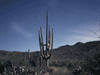
| My wife wasn't sure she wanted to go on this trip, but was almost glad she did when we hit miles of snowscape. The snow wasn't deep but everything was dusted with the white stuff. A short section looked like an endless Christmas Tree lot of little snow covered trees. I took a few photos around the small town of Madeline and then we crossed the county line and finally entered the destination county of this trip. The trees and snow stopped almost at the county line as we descended to the expansive valley below. |
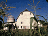
| A few minutes into Modoc County I stopped to take a few photos in the town of Likely with a cluster of old buildings that almost looked like a historic park, but not quite. We pressed on to Alturas, stopping first at the Modoc County Historical Museum. I thought this would be a good place to get information on other historic points of interest in the area, but it seems Modoc County got itself into financial trouble and there are not funds for many vital county services, including the museum which was closed. I photographed the Southern Pacific steam locomotive in a fenced enclosure behind the building and couldn't do much more. Disappointed, we checked into our motel and ate lunch. The sub sandwich shop is next to the old railroad depot, now Elks Lodge, a beautiful dark stone building on Main Street. With our plans altered by the closed museum, we continued north on Highway 395. |
 Museum is closed. |
| Not far north of Alturas I noticed three derailed railroad cars upside-down on the side of the railroad embankment. A few minutes later, when I stopped to photograph an old barn and noticed in the distance, a row of several more railroad cars on their side. I noticed several other places where equipment or railroad ties were on the track making me think that this line has been abandoned, but made for some interesting photos. |
| We reached the border town of New Pine Creek and followed State Line Lane to a small Oregon State Park on the edge of Goose Lake. On the map, Goose Lake is quite large, but it is a shallow lake and the area covered changes greatly with rain and snow levels. Today it didn't look very large. We continued another mile to the "Welcome to Oregon" sign, photographed it, and returned to Alturas a bit before sunset. |
| We drove and walked around Alturas in the cold fading light to view several historic points of interest. A sign pointed to a historic point of interest which we assumed was the Catholic church as we couldn't find anything else on that street that looked old. The Courthouse is a domed structure typical of other county courthouses, a small pioneer cemetery overlooks farms stretching to the south, and the historic Niles Hotel had closed a few years before. The Niles was another sight we had hopped to see so Alturas was a little disappointing. Maybe things will improve. |
| We enjoyed a wonderful dinner at Antonio's Italian Restaurant, and retired to our motel. |
| Day 3 - Lava Tubes and Old Friends |
| The third day began with a quick continental breakfast and then one last quick look around the town of Alturas. There are several murals on the sides of some buildings and I photographed some more of the historic buildings in the early morning quiet. We checked out of the motel and headed west to meet a friend at Lava Beds National Monument. While driving through the Town of Camby, we were impressed by several holiday themed life-size dioramas beside the highway. There was an elaborate Thanksgiving diorama and Christmas dioramas. This must be some undertaking for a small town. |
| The desk clerk had suggested entering the park from the north because the road to the south entrance wasn't well maintained. We've driven worse roads and followed the south road (Lava Beds National Monument Road) into the park without incident through picturesque scenery. The road suddenly improved as we crossed the monument boundary and county line and said goodbye to troubled Modoc County. We were supposed to meet my friend at 10:00 and we were both early so I bought an National Park annual pass and we began our adventure. A few steps from the Visitor Center is Mushpot cave which we were told is one of the easiest and is 770 feet long. My wife wore for the first time the official Lava Beds hard hat that I bought for her years earlier during our first visit at which time she waited in the car. This time she enjoyed this easy cave with a lighted trail, interpretive signs, and what looked like a seating area maybe for ranger talks?. There were a few places with a low ceiling, but most of it is easy. The lave tubes were created as molten lava flowed in rivers from the volcano's vent, following the natural route as a stream might flow. The edges of the flow cooled before the inside which kept flowing as a cooled crust formed on the outer edge, creating long twisting downward traveling tubes. The flows would branch off, combine, split and rejoin, always moving down hill. In many case one or both ends would collapse and there may yet be undiscovered tubes with no remaining openings to the surface. One tube that is collapsed at both ends is Golden Dome cave. |
| We drove the loop road to Golden Dome cave, the one I partly explored alone during my previous visit when my friend had to cancel at the last minute and my wife stayed in the car. This time she also waited in the car, but at least I had my friend and we explored several branches of the downstream section to the ends. The only way into the cave is through a hole in the ceiling with a narrow ladder and a tight squeeze. The cave takes its name from what looks like small crystals of gold in the ceiling. Actually the gold is bacteria that takes on a golden glow under flash light illumination. Most of the caves are natural with no lighting and rough floors. One should be careful not to get confused as the passages branched in different direction. At one point, I left my camera tri-pod as a marker to which way we came. The ceiling was often covered with lavacicles, icicle-like drips of cooled lava trapped in time. The floor was littered with material that fell from the ceiling and there were many cracks in the floors, ceilings, and walls. As we exited the cave we were surprised to realize that we had been in the cave for almost two hours stumbling over the rough floor and marveling at the formations. This cave is listed as moderate challenge at 2,229 feet . The park recommends each person takes two flashlights and this is good advice. You would not want to look for a dropped flashlight in he dark or find your way out without one. |
| There are a number of caves along Cave Loop Road but we hadn't the time to explore them all so we headed off to Valentine Cave which was similar to the others, but formed from a different lava source. This time my wife reluctantly went into the cave with us but found the footing uncomfortable, but then she stumbles on textured carpet. We wandered back some distance before, as a courtesy to my wife, only about half way back we returned to the surface. Valentine Cave is listed at 1,635 feet. |
| We decided we didn't have time to see any other caves and headed north out of the park, stopping just at the edge of the park at the Canby Cross commemorating the spot where Canby was killed. This was the same Camby for which the town we passed through earlier had been named. We continued north through Tule Lake National Wildlife Refuge where we stopped to watch three deer drinking from a roadside puddle. We traveled west along Highway 161 which runs parallel to the California-Oregon border just a few feet on the California side. We caught US Highway 97 and continued south to I-5 with a few stops along the way. We had lunch and said goodbye to my friend in Dorris, a small town that boasts the tallest flag pole west of the Mississippi River. We stopped a minute at Living Memorial Sculpture Garden but it was getting dark and we were trying to reach Redding by 5:30. I stopped beside the road to photograph Mount Shasta which dominates this part of California and only the snowy top was picking up the last rays of sunlight. |
| Once joining Interstate 5 at Weed, we continued to Redding, our destination for today ariving a bit after 6:00. It took a while to find Sundial Bridge which we photographed and walked across. I had discovered this engineering art piece a year earlier when I saw the top few feet from I-5 but realized it was something special. A 217-foot pylon acts as a sundial casting a shadow on a white broken tile garden wall beyond from 10:00 AM to 3:00 PM, but is accurate only on June 21, the Summer Solstice, because unlike a small sundial, this bridge can not be adjusted. The bridge was designed by architect Santiago Calatrava and is a 700-foot long pedestrian bridge joining the banks of the Sacramento River with minimal impact on the ecosystem. The bridge is spectacularly lighted at night and features a glass deck. A group of women were singing at the small amphitheater under the north end. |
| We found our motel and my wife was delighted to find it had a whirlpool tub of which she took advantage. We drifted off to sleep dreaming of our trip home tomorrow. |
| Day Four, the Slow Way Home |
| The last day began well enough. We were second in line at the continental breakfast and by 7:30 we were back at the Sundial Bridge, only now it was highlighted in early morning sunshine bouncing off the white metal and white broken tile. Today we could see the Sacramento River below which we could not the night before. The whole area on one side of the river is considered Turtle Bay Exploration Park and it turns out that there are miles of riverside trails on both sides and a Botanical Garden on the other, in addition to the bridge. The Turtle Bay Museum is part of the Exploration Park. The Convention Center is on the other side of the parking lot. We easily could have left the car in the lot and spent the whole day here, but unfortunately, we had to move on. |
| I had a little trouble finding the City Hall, but this beautiful modern building has a sculpture garden in front that made it worth the effort. Two sculptures of wood fascinated me as a woodworker and I liked the several involving insects. The Gatherer is something unworldly, maybe an extraterrestrial from a planet without rocks. Carved rocks were the subject of several other sculptures as well. We were pressed for time but we think we found them all before we hurried off. |
| On the way to Mass at Saint Joseph Church, we noticed a Planetarium so added that to our list of sights the next time. I was a little frustrated finding my way back to I-5. Several times I followed the signs instead of trusting my instinct and got lost, only to find my instinct had been right. Eventually we were heading south again and waved goodbye to Redding, hoping to return when we had time to stay a spell. |
 Saint Joseph Church |
| We continued south, stopping for gas and a few rest areas and debated about whether we would arrive home by 6:00 or 8:00. Then a little south of Stockton, we hit traffic. I exited I-5 and took California Highway 33 which I had traveled years earlier when we had time for the slower road. It is quiet and uncrowded and passes through picturesque farmland. Only this time we were averaging |
 Not moving very fast. |
| 50 MPH while I-5 was averaging only 20. We got back on I-5 at Santa Nella and off again 5 miles later. We headed east through the historic town of Los Banos (The Baths) to pick up another section of Highway 33 and followed it south, back to I-5 by which time things had improved. I don't know if we saved any time, but the view was nicer and it was comforting to keep moving. We hit traffic a few more times but there were no more good alternate routes so we tried to stay awake as we crawled along south. We exited I-5 a few miles early and had a traffic free end to our trip about 9:30. Two of our cats were glad to see us, the third always forgets us until the first hug, then she remembers who we are and keeps close. We traveled about 1500 miles to the Oregon border and back, drove though about 20 counties in California, including two for the first time, and a few in two other states. We drove Highway 395 from about Ridgecrest to the Oregon border. We got a little snow, some rain, and some sunshine. Some of the historic sights and museums we had hoped to see were closed but we found other points of interest. My wife thought is was a bit long and we are not likely to go this far in such a short time again. But we did visit Modoc County at the northeast corner of California, a county most Californians have never heard of. | |

|

|

|
| Note:This is not the official site for any of the places shown in Places Earth. Places Earth is not responsible for accuracy of the information. Hours of operations, prices, exhibits, and sometimes locations are subject to change without notice. |
|
Support this Web Site I hope that you find this web site helpful. It started because of my love for Architecture and interest in History and a desire to share my photographs and tales of my adventures. I don't allow paid advertising. This web site is for your benefit and enjoyment and I make no profit on it. For twenty years it has been supported primarily from my regular paycheck as a Set Designer. If you are in the need of a designer, please see my Set Designer portfolio site Set Design Portfolio. |
|
Links |

|
This site maintained by Kenneth A. Larson. Copyright © 2004 - 2023, Kenneth A. Larson. All Rights Reserved. Website content including photographic and graphic images may not be redistributed for use on another website. |

|

|

|