Places, Earth
Road Trips, Santa Barbara, California
Road Trips, Santa Barbara, California
|
|
Places, Earth
Road Trips, Santa Barbara, California |
|
|
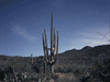
We have taken several one and two day trips to the beautiful City of Santa Barbara. Growing up, I thought that Santa Barbara was a world away from Los Angeles. Recently I learned that it only feels a world away, by car, it's only 90 minutes from my home in the San Fernando Valley. Santa Barbara is rich in history and in the summer of 2004, I alone, or my wife and I, ventured to Santa Barbara for six day trips to study this wealth of history. Driving north on US 101, you actually drive west for an hour before turning north at the City of Ventura. Ventura itself makes a wonderful day trip, but that's another story. About twenty minutes north of Ventura is the town of Carpenteria, itself filled with historic sites. Ten minutes more, and we are in Santa Barbara. |
| Probably the best known historic site in Santa Barbara is the Mission. Mission Santa Barbara is called "The Queen of the Missions" and seeing the church, made of sandstone is breathtaking in the pink light of sunrise. Mission Santa Barbara is the only mission with matching bell towers and it is a grand facade. Enter the Museum through the Gift Shop to the left of the church. Within the museum are exhibits and restored rooms. Enter the central courtyard to see the garden and the caretta. Unfortunately, visitors are not allowed in the garden, but it can be seen from the edges. Enter the church from the quadrangle through the side door. The church is one of the larger and most beautiful of the mission churches remaining, masses still held regularly. Continue your tour through the door in the other side to the Cemetery and then back to the Church forecourt. Across the street and a wide lawn is the almost missed rose garden. |
|
After touring the mission, don't miss Mission Park. Only a few feet way, it's is often missed by the bus loads of tourists who come to see the mission. Santa Barbara is one of the few missions that are still surrounded with the ruins of the out buildings such as the Pottery Shed, the Tannery, grist mill, reservoirs, filter, and aqueduct that supported the missions. Mission Park is under the jurisdiction of Parks and Recreation and is an undeveloped collection of ruins. A low stone wall makes the edge of Mission Park. This wall turns out to be part of the aqueduct system, of which we will see more later. The first ruin we encounter is the Tannery. Only the lower few feet remain. Continue along the trail to the jail, across the street to the Pottery Shed. It is here that you may find a map of the park. A few steps to the large reservoir, then the grits mill, and the upper reservoir which provided water to the mill. Walk around the upper reservoir and a bit beyond is more of the aqueduct and the filter, a building where sediment could settle out of the water before entering the aqueduct. The filter as well as several other of the ruins are now covered with grasses and other plants that found a place to root between the stones that made up these constructions. It reminded me of Classical Renaissance paintings of vegetation covered Roman ruins. Do take care crossing the streets as there are no cross walks and cars come around the curves quickly. As long as you are at the mission, it's only a short trek to the Natural History Museum or the Botanical Gardens. |
|
The Santa Barbara Natural History Museum includes nine exhibit halls spread over several buildings, the Gladwin Planetarium, Butterfly Pavilion, and a 72-foot whale skeleton. Exhibits center around, but are not limited to, local history. The museum conducts research in addition to it's educational mission. Watch the signs carefully to find the Santa Barbara Botanical Gardens. These gardens are of native plants and since Santa Barbara is a semi-arid environment, these plants are drought tolerant. There is a forest of redwoods and a stream. It is this stream that is responsible for another piece of the mission story. The trial crosses the stream over the remains fo the Mission Dam and beyond is another filter and some more aqueduct. Continue along the path and either cross at the bridge or continue to the end and cross the stream on stones. My wife was reluctant to cross the stones, so we backtracked to the bridge. Don't miss the section across the street. When Spain settled Alta California, they built the well known 21 missions, but also built four Presidios, and three Pueblos. Santa Barbara was the location for the last Presidio. The intersection of Santa Barbara Street and Canon Perdido Street is now within the former Parade Grounds. About two blocks south of the Presidio is Casa de La Guerra, which was the home of the fifth Presidio's Comandante, José de la Guerra. The house was built in 1819 to 1827. The house was a civic and social center for Santa Barbara. In 1922-23, the El Paseo complex of shops and restaurants was built around the Casa in a blend that works better than most I have seen. Following the 1925 earthquake, the Casa served as a guide for rebuilding the city in style we see today with the red tile roofs so prevalent when viewed from the City Hall Tower. The Santa Barbara Trust for Historic Preservation is maintaining and studying the site today. Casa de La Guerra is located at 11-19 East De la Guerra Street, and is open Thursday through Sunday, 2:00 noon to 4:00 p.m. Santa Barbara Historical Museum was built in 1965 in the Mission style by the Santa Barbara Historical Society which was founded in 1932. The day we visited, the galleries displayed a collection of Mission Paintings and other art work. Behind the Museum are two adobes, Casa Covarrubias, 1817 and Historic Adobe, 1836. The first time we visited, a wedding reception was about to start between the two adobes, so I had to come back another time for my photos. The Museum is at 136 East De la Guerra Street, about two blocks east of Casa de La Guerra. The museum is free, but donations are accepted. |
|
We learned of the County Courthouse during a previous trip, but it was a priority this time. The most popular feature is the fifth floor observation tower. Santa Barbara is not a high-rise city and from the observation tower, the visitor views a sea of red tile roofs. When the skies are clear, you can also see the sea and several of the Channel Islands. To the northwest, the Mission and the towers of Saint Anthony's Seminary are easily visible. Inside, don't miss the Meeting Room on the second floor, the grand corridor on the first floor, and indoor/outdoor spiral stair. On a later trip, I stumbled into a Democratic political rally in the large lawn behind. Outside, the building is covered with architectural details such as a turret, the bridge to the old third floor jail, and intricate carvings. My wife loved the fountain in front. The lawn was so green, it looked like the photo was retouched, but I was seeing it with my own eyes. The Spanish-Moorish styled Santa Barbara County Courthouse is between Anacapa and Santa Barbara Streets and between Anapamu Avenue and Figueroa Street, only two blocks from the Presidio. It's only a short walk to the Santa Barbara Art Museum on State Street. Santa Barbara is filled with art and culture. We found a 90 minute parking space a block from Stearn's Wharf and walked to the end of the pier. My wife loves the dolphin fountain at the base of the pier and several veterans were collecting donations for displaying their sand sculptures, some of which were well executed. Piers and lighthouses are probably the best loved pieces of costal architecture. Stearn's Wharf is old and filled with character. A typical wood structure, it is lined with shops, restaurants, and fishermen. You can see the waves through the spaces between the boards that make up the deck and there are no railings around the end. My wife stayed at least ten feet back from the edge. A new oceanographic discovery center, part of the Santa Barbara Natural History Museum, was under construction when we visited in late June of 2004. It's scheduled to open later in the year. |
|
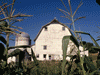
We had more difficulty finding the famous Morton Bay Fig Tree than we had expected because of the one-way streets and dead-end street. Only a few feet west of the Amtrak Train station, we could see it from a distance and couldn't get to it because it's squeezed in between the rail road and the freeway and most of the street don't go through. The tree is on Montecito Street, but this street crosses over State Street and it takes several blocks and turns to connect the two. Despite the difficulty we had finding the tree, we were glad that we did. The tree is one of the largest Morton Bay Fig Trees in the country. The Australian tree was planted a century ago by a young girl a few blocks away and the tree was later moved to its current site. The crown measures about 175 feet across and the base is about 35 feet at ground, about 15 feet at a height of four and a half feet. A fence keeps visitors from damaging the root system. Although a fig, the leaves and fruit are quite different from the two fig trees in my own yard. The flyer said, "Fernald Mansion," but actually this is only the grandest of the two historic houses on the site. The other house, The Trussell-Winchester Adobe, is older and sits on the original site. The Fernald Mansion was moved to this site a few decades ago. The Trussell-Winchester Adobe was built by Captain Horatio Trussell in 1854. It is unusual in that it is built of traditional adobe walls, but has a wood rather than traditional tile roof. Many of the timbers used in the house came from the wreck of the sailing ship Winfield Scott which ran aground in 1852. Horatio had ten children and in 1868, he built a second house about a mile away which is now gone. The house was acquired by a man named Eddy who sold it to Mr. Winchester in 1882 who added on to the right side that year. Walking into the master bedroom, you can feel the slope of the newer floor. In 1902, Mr. Winchester added a study and laundry room to the left side of the house. Both of these additions were of wood construction which was by then the popular. While touring the house, we saw how women of the day kept in shape, using the hand turned butter churn and the hand pumped washing machine. The Winchester family owned the house until 1952 and there are no members of the Trussell family known to live in Santa Barbara. Although the Fernald Mansion was built only nine years after the Trussell-Winchester adobe, the construction is very different. The Fernald Mansion is a Queen Anne Victorian with all the trimmings. When I asked if there were plans to paint the exterior more colorfully as was the fashion at the time, I was informed that it is the original beige color and the owner, Judge Charles Fernald, was a modest man. Judge Fernald was in love with a society woman form the east and built this house to entice her to come west and presented the house to her as a wedding gift. Charles had been studying law in San Francisco when his home and law books were destroyed by fire about the same time as his place of employment was also destroyed by fire. He decided to return east but stopped to visit a friend in Santa Barbara on the way. The friend persuaded him to become Sherif which lead to a job as District Attorney, then Judge with a little lawyering along the way. Eventually, he became mayor of Santa Barbara. The family lived in the house until the 1950 when a descendant of Charles gave the house to the Historical Society rather than let anyone else live in the family home. These two historic houses are only a few blocks west of the Morton Bay Fig Tree. Docent lead tours depart at 1:00 p.m. and 2:00 p.m. The houses are operated by Santa Barbara Historical Society and are located at 414 West Montecito street just west of Castillo Street between the freeway and the sea. |
|
Just a few blocks from the Trussell-Winchester adobe and Fernald Mansion at 129 Castillo Street is the Carriage Museum. Not realizing that the museum is at the back of a parking lot beside a park, I drove past the first time. The museum was worth driving around the block for a second try. The building is an L shape. The vertical part is the old stable for the old horse drawn street cars, the cross piece is newer, but still several decades old. These two sections are filled with wagons, carriages, and tack. One of the most interesting wagons, for me, was a highly detailed carved wood wine barrel wagon. Just down the street another block is the Maritime Museum. The Santa Barbara Maritime Museum opened in July, 2000. In addition to the model boats and artifacts that are typical to maritime museums, this museum has several fine exhibits on the Channel Islands just a few miles offshore. The museum also has exhibits to the offshore oil production also found in the Santa Barbara Channel. The museum looks over the harbor which is filled with boats of various sizes and varieties. I lost count of all the seafood restaurants. Next door to Santa Barbara is the City of Goleta. Also rich in history, this will be the subject of another article soon. My personal interests are historical sites and buildings, but if you want to add a little extra fun to your trip to Santa Barbara, there are beaches and water sports in the Harbor, art galleries, shops and restaurants throughout the city, and two Wineries, one "by the beach" and another 40 minutes north in Santa Ynes. While it may not be an historical landmark, a visit to Santa Barbara would not be complete without a trip to the Santa Barbara Zoo. Along side Highway 101 on the ocean side, the zoo is on the southern end of town making it convenient for people visiting the zoo only. While not as large as the two big city zoos south (Los Angeles and San Diego), the Santa Barbara Zoo is one of the nicest small zoos I've visited. So visit Santa Barbara some time, maybe you'll see me. I'll be the one with two cameras around my neck. |

|

|

|
| Note:This is not the official site for any of the places shown in Places Earth. Places Earth is not responsible for accuracy of the information. Hours of operations, prices, exhibits, and sometimes locations are subject to change without notice. |
|
Support this Web Site I hope that you find this web site helpful. It started because of my love for Architecture and interest in History and a desire to share my photographs and tales of my adventures. I don't allow paid advertising. This web site is for your benefit and enjoyment and I make no profit on it. For twenty years it has been supported primarily from my regular paycheck as a Set Designer. If you are in the need of a designer, please see my Set Designer portfolio site Set Design Portfolio. |
|
Links |

|
This site maintained by Kenneth A. Larson. Copyright © 2004 - 2023, Kenneth A. Larson. All Rights Reserved. Website content including photographic and graphic images may not be redistributed for use on another website. |

|

|

|