Places, Earth
Road Trip to Santa Cruz
Road Trip to Santa Cruz
|
|
Places, Earth
Road Trip to Santa Cruz |
|
|
Day One, Long Journey North I got married so I would have someone with whom I could travel. For the third trip in a row, my wife chose to stay home with her dogs. I headed north with Francine, my 21 year old Sable station wagon. We traveled north on I-5, noted how the mountains are green in the Spring, skipped Tejon Pass Safety Rest Area, and descended into the majestic San Joaquin Valley. |
 Alfalfa field east of the northbound side of the Buttonwillow Rest Area along Interstate 5. I continued north on I-5, stopping a half hour at Buttonwillow Rest Area. I photographed a field of fresh cut Alfalfa and almond trees beyond, and a few shots of the rest area. I continued north through the San Joaquin Valley listening to Sons of the San Joaquin |
 Inforfmational kiosk at the northbound side of the Buttonwillow Rest Area along Interstate 5. |
| and turned west onto Highway 46. The highway passes through the Midway-Sunset oil field, the largest oil field in California and the third largest in the United States. As I climbed out of the San Joaquin Valley, the CD switched to Gordon Lightfoot. | |
| As I drove west on Highway 46 through rolling hills, just before reaching Highway 101, my wife called to tell my she broke her car key and asking where I kept my key. I stopped for gas in Paso Robles at Highway 101 and Highway 46. As I inserted my credit card into the pump, I received a cell phone call, "This is Sarah at Discover..." Click. I headed south on highway 101 to catch another leg of Highway 46 west. I stopped at a scenic overlook of Morro Bay in the distance. I merged onto Highway 1 going north. |
 Looking south to Morrow Bay and Morro Rock from Highway 46. |
 Piedras Blancas Light in the Lions Club lot in Cambria. |
 Front of Nitt Witt Ridge. I missed the tour by five minutes. I drove through Cambria and stopped to photograph the light from Piedras Blancas Light House. The fresnel lens stands alone while the lighthouse, with a modern light, is many miles north. I was hoping for a tour of Nitt Witt Ridge but missed it by 5 minutes. |
| I continued north on Highway 1 stopping at numerous vista points, including one looking down on Elephant Seals. I noticed a little fog off shore hiding large offshore rocks as I continued north. I crossed the county line into Monterey County continuing along Highway 1 and passed stunning coastlines, crossed beautiful bridges, including the famous Bixby Bridge, and observed eroded hillsides. | |
 Elephant Seals on a beach north of San Simeon. |
 Bixby Creek Bridge is possibly the most photographed single object along this section of the coast. |
|
Finally I entered Carmel, drove through Monterey, Moss Landing with its fishing fleet, and other towns lining the shore of Monterey Bay. About 5:00 PM I reached my motel. After a few minutes to unload, I began my search for Branciforte. Branciforte was the third and final pueblo established in Alta California by the Spanish. There is nothing to be seen today, just a marker in front of a school to commemorate the site of the town established in 1797. I photographed the marker and drove to |
 This marker says that this school sits on the original location of the Pueblo of Branciforte. |
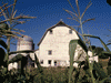
 The entrance to the Family Housing and Santa Cruz Mission State Historic Park. Mission Santa Cruz. By now the Mission was closed but I had seen it before so I shot a few photos of the exterior and returned to my motel. I would return to the Mission on Sunday. |
| I enjoyed dinner and worked on my photos and this article as I watched a movie. I drifted off to sleep thinking of coastlines and highways. |
|
Day Two, Trains, Lighthouses, Piers, and Banana Slugs I awoke to a rattling sound. I decided it was outside and opened the door to realized the sound was a dripping rain gutter down spout. It was raining and I had no rain gear. I got ready for breakfast, went outside, and managed to get my breakfast to my room between raindrops. I ate breakfast, got ready, and left for the day. I had an umbrella and hat in the car, so it was OK now. I pulled out of the motel driveway and turned right. Ten minutes later I was where I started and went straight this time. It was easy once I was on the correct (straight, not right) road. | |
 Through this covered bridge lies Roaring Camp Railroads, trains, and redwood trees. | It was only a few minutes to Roaring Camp Railroads and it started raining again half way there. I don't mind a little rain, but the cameras don't like it. I slogged through the mud but eventually reached the station, crossing a covered bridge, and passing interesting displays and pieces of equipment. I got my ticket and wandered an hour taking photos in the rain. I had reserved the 10:30 train but the 10:45 was canceled and the two trains were combined. I don't think too many were detoured by the rain so the one train was full. I sat in an open side covered car, still getting wet, but everyone enjoyed it anyway. I think |
|
the rain enhanced the effect. About 10:45 the train departed into the redwoods. I was in the first car of a six car train. We were warned to be careful of a "magical plant" that causes a "magical rash," poison oak. Poison oak has a cluster of three leaves, let it be. If a plant has three leaves and is harry, it is a berry (wild cherry). We were entering into both logged regrowth and old growth California Coastal Redwoods. These trees can grow 250-380 feet tall. We |
 This mighty Shay pulled the heavy train up a steap grade. |
|
crossed a bridge believed to be the tightest curved bridge in North America. The mighty Shay locomotive slowed as it climbed an 8.5% grade and the wet rails didn't help. The narrator explained that the frequent whistle blasts, long, long, short, long is because at all grade crossings, no matter how minor, trains are required to make this signal and there were several little used dirt roads.
The Shay continued pulling our train up the steep grade. At Spring Canyon we were told how originally a 360 degree curve trestle was used to gain altitude, but the bridge was destroyed by a fire in 1976. The track was rebuilt with a switch-back with a 10.5% grade, the steepest in the country. We experienced this switchback twice, going up and again going down. We were told they now call this grade Hallelujah Mountain because they cry hallelujah if the train makes it to the top. It sometimes takes multiple tries to get up the grade. | |
 This 360 degreee bridge was destroyed by fire in 1976.. |
As we passed through Slug Alley we were told of the yellow Banana Slug that lives only in these temperate rain forests. Bear Mountain is the top and turn around. It was Easter weekend and there were many children's activities at the top. After a ten minute stop so children could look for Easter eggs and train buffs could look at the locomotive, we reboarded and departed. The train is equipped with a Westinghouse air break. Air pressure is used to keep the breaks |
| open. In the event of a pressure loss, the breaks close and stop the train. Before these were mandated by law over a hundred years ago, accidents were more common. We went through the switch-back again and continued down. When we reached the station, one final short whistle blast let us know it was time to get off the train and make space for the next group of eager passengers who got on as we got off. |
 The switch-back replaced the bridge that was destroyed. |
 Tree branches growing vertically. could photograph these trees was to take many stills to composite later or a video panning up the tree. |
After a quick trip back to my car and the restroom, I followed a suggestion to walk a few hundred feet to Henry Cowell Redwoods State Park with its .8 mile hike through the redwood trees. The hike was as you might expect as it wound through these giant trees. It was here that I finally saw a Banana Slug hiding on the back of a tree. The only way I  I finally found a Banana Slug. |
| From here I slogged back to the car through all the mud again, but at least it had stopped raining and was sunny the rest of the day. I stopped at my motel a few minutes to regroup, then off to Natural Bridges State Beach. There is a day fee for the beach, but 20 minutes free parking to just see the natural bridge which is an off shore rock with a hole worn clear through. It took me 15 minutes to hike down, take a few photos, and struggle back to the car. |
 Natural Bridges State Beach. |
 Santa Cruz Lighthouse and the Surfing Museum. | From here is was only five or eight minutes to Santa Cruz Lighthouse and the Surfing Museum within. I don't surf, but it was still interesting to see the early all wood long boards surfers once used. The lighthouse still works but is no longer operated by the Coast Guard. I stopped a few minutes to talk with a man flying a two-string kite which could do all sorts of maneuvers. It was easier to control than a conventional kite. I had two more stops for today so I continued on my way to Santa Cruz Wharf. |
| Technically the wharf is really a pier, but so is Fisherman's Wharf in San Francisco, Monterey, and I'm sure many other places. The pier extends out into the bay a little over a half mile and is the longest wooden pier in the United States. The pier, built in 1914, has shops and restaurants lining much of one side and parking on much of the other. I found parking about the middle and walked to the end taking photos of the pier, back at the Santa Cruz Lighthouse, and at the Santa Cruz Boardwalk. There were places to see the seals lying lazily on |
 Santa Cruz Wharf. |
| various horizontal braces near the waterline. They reminded me of my lazy Chihuahua at home. Before I left the pier, my main reason for coming, was Marini's Candies where I bought several pieces of Chocolate Covered Bacon in two flavors. I had been hearing about these treats for several years and had to try a piece (or several more and some almond clusters). This mission accomplished, I had one last stop today. Parking at the pier is $1.00 for 20 minutes which is better than $25.000 for all day at the Boardwalk where I went next. | |
| I found a parking space in the street four blocks from the Santa Cruz Boardwalk and got some exercise. It took a little time to find the first of several passes from the street to the boardwalk and then I entered the Boardwalk. I started with the colonnade then turned around and walked the entire midway. It is mostly open or small venues on the sea side and all the big rides are on the street side with a cluster at the end against the river. I don't remember all the names but the big roller-coaster I think is the Dipper. There are many of the usual spinning rides but also the sky baskets and a train. If my wife hadn't boycotted the trip, we would have done the latter two and I would have done the roller-coaster alone. I took more photos and walked back and found my way out. Fortunately I remembered where I left the car. | |
 The SantaCruz Boardwalk from the Santa Cruz Wharf. |
 The Sky Glider at the SantaCruz Boardwalk. |
|
With all but one of the objectives met for this trip (last one tomorrow morning), it was time to return to the motel. I enjoyed a quiet dinner, watched a video, sorted my photos, and worked on this article until my eyes wouldn't stay open. Day Three, Be Home by Two |
|
Easter Sunday began like most, everything else was different. I got ready and ate, started packing, then left for Easter Mass at the modern church that replaced Mission Santa Cruz. I returned to the motel, packed, checked out, and at 8:45 I headed home. I started out following my Mapquest directions, zig-zagging through back roads until I got lost. The Maps on my phone got me heading in the right direction. Finally on Highway 101 I was moving, in the wrong direction. Once turned around, I finally reached Highway 156. |
 This small pile of ruins is all that remains of the original Mission church. Also a small remnant of the cemetery is beyond. |
|
I traveled east until I arrived at Casa de Fruta, an oversize fruit stand with wine shop, rides, camp grounds, restaurant, and more. After buying candy, popcorn, fruits, and other things, I continued east on Highway 152. I saw deer to the left, two trucks carrying three wind terrine blades, and as I passed San Louis Reservoir, I saw a few elk to the right. At last I was traveling south on I-5. The first rest area, just north of the Merced and Fresno County line, was closed. I cruised past orchards and fields, despite the drought, the Central Valley still produces much of the nation's food. I stopped at Colinga-Avenal Rest Area and Buttonwillow Rest Area where I photographed what I think were almond trees. Thankfully there wasn't the same traffic as some other 3-day weekends. I got gas at Wheeler Ridge and started up the Grapevine. Sons of the San Joaquin was still playing as I climbed the Grapevine out of the San Joaquin Valley. |
 Decorative water wheel at Casa de Fruta. |
 What I think are almond trees beside Buttonwillow Rest Area in Kern County. |
My old car roared up the steep grade with no problem but just as we reach the top, I again received the same transaxle error light I had received the first day of the February trip. When I restarted the car at home, the light was off again. A few days later my mechanic found no problem with the transaxle. At last I arrived home where my family seemed happy to have me home. The next day my cat and two dogs took turns sitting on my lap. I had been planning this trip for several years and it was nice to |
| cross a few things off my bucket list. I am very interested in the Spanish Missions and related settlements in the United States and Branciforte was the last of the three Pueblos in California and despite not much to see, it wrapped up that subject. Till next time. | |

|

|

|
| Note:This is not the official site for any of the places shown in Places Earth. Places Earth is not responsible for accuracy of the information. Hours of operations, prices, exhibits, and sometimes locations are subject to change without notice. |
|
Support this Web Site I hope that you find this web site helpful. It started because of my love for Architecture and interest in History and a desire to share my photographs and tales of my adventures. I don't allow paid advertising. This web site is for your benefit and enjoyment and I make no profit on it. For twenty years it has been supported primarily from my regular paycheck as a Set Designer. If you are in the need of a designer, please see my Set Designer portfolio site Set Design Portfolio. |
|
Links |

|
This site maintained by Kenneth A. Larson. Copyright © 2004 - 2023, Kenneth A. Larson. All Rights Reserved. Website content including photographic and graphic images may not be redistributed for use on another website. |

|

|

|