Places, Earth
Sepulveda Boulevard, the Longest Street in Los Angeles
Sepulveda Boulevard, the Longest Street in Los Angeles
|
|
Places, Earth
Sepulveda Boulevard, the Longest Street in Los Angeles |
|
| Have you ever given any thought to Sepulveda Boulevard, the longest street in Los Angeles? The other day, while stuck in traffic, I knew I was only a few blocks from the north end and I wondered where the south end was. So, I pulled out the Los Angeles/Orange County Thomas Guide and started at the north end and followed, page by page, all the way to the end. Just to make it more interesting, I followed it through all the name changes, as long as the street continued straight through the intersection and didn't turn in the intersection as the name changed. That is, if you were to drive through the intersection and not notice that you were on a street with a new name without looking at a sign, then I considered it the same street. |
| Sepulveda actually was once a little longer than it is today. Today Sepulveda begins at the north side of the San Fernando Valley at Rinaldi Street (mile 0). If you were north bound on Sepulveda and crossed Rinaldi Street, you would climb the on-ramp to Interstate 405, the San Diego Freeway, north. Before the freeway was built, Sepulveda continued north of this point a few miles further ending, or beginning, at San Fernando Road. About a mile of this stretch still remains as a frontage road to Interstate 5, the Golden State Freeway. The mile between is now under the Golden State and San Diego Freeways and lost to us. |
|
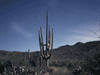
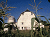
So, we begin at San Fernando Road, near the Golden State Freeway in Sylmar. The freeway is to the left and the Los Angeles Reservoir is to the right. Not much is happening here and within minutes, we reach Roxford and the end of this stretch. We get on the Golden State Freeway and within seconds, transition to the San Diego Freeway and travel south, above the former roadbed of Sepulveda, to Rinaldi about a mile and exit. A quick left and right turn and we are on the longest stretch of Sepulveda Boulevard. So here we go. We immediately pass the first of four cemeteries that we will see along our journey. We only travel about two blocks more before we pass Andrea Pico Adobe. Sepulveda runs almost straight south through the San Fernando Valley, with a slight jog to the east after Roscoe Boulevard. This stretch is almost entirely commercial. In fact, our trip will almost entirely pass through commercial and industrial areas. Sepulveda passes under US 101, the Ventura Freeway, and crosses Ventura Boulevard. Sepulveda leaves this first straight section and begins its most twisted section. |
| Most of the people traveling from the San Fernando Valley to the "West Side" do so on Interstate 405, but a few use Sepulveda Boulevard to travers the Sepulveda Pass. First Sepulveda passes under Interstate 405 to the west side, then later, it will cross back to the east side again. After crossing the 405 the first time (mile 10), we begin this winding section which passes through a residential area, one of the few we will see on this journey. Besides the twists and turns, there is also the only real tunnel (mile 12.1). Mulholland Drive passes overhead, but this is not a bridge, it's a real tunnel through the mountain. The pass is the least densly developed section of Sepulveda. We emerge from the tunnel to see the Skirball Cultural Center on the right. A few streets branch off to residential areas. We cross back to the east side of the 405 at mile 14.5. Sepulveda runs past the New Getty Center (mile 15.2) and then leaves the pass that shares its name as it passes under famous Sunset Boulevard. (mile 16) |
| Sepulveda Boulevard roughly parallels Interstate 405, the San Diego Freeway for much of its route and enters the Los Angels Basin passing between Interstate 405 and Los Angels National Cemetery (mile 17.5). Sepulveda ventures through West LA, crosses Wilshire Boulevard, sometimes caled the Main Street of Los Angeles, and passes under Interstate 10, the Santa Monica Freeway, then continues through Culver City. While this section does generally travel straight, it does have several gentle curves. |
|
Suspulveda makes a gentile curve about half way to the right as Jefferson Boulevard branches to the east (mile 23.1). Had we been going north, we would have to stay to the left through the curve to stay on Sepulveda as Jefferson curves to the right. Sepulveda continues south and under State Highway 90, the Marina Freeway. Now we see Jefferson Boulevard again, this time branching to the west. Once past State Highway 90, Sepulveda crosses under Interstate 405 for the third time (mile 24.2), continuing south as the freeway moves southeast. |
| Not only does Sepulveda pass near the Los Angels International Airport, not to be daunted, it passes under the runway (27.2). Sepulveda Boulevard, which has been a Los Angels street for almost 28 miles, enters the city of El Secundo (mile 27.6). |
|
Sepulveda acquires a number, State Highway 1, just as it entered the airport area and now carries the number through El Segundo, Manhattan Beach, and changes its name for the first time at the edge of Hermosa Beach at Gould Avenue / Artesia Boulevard (mile 31.7). Follow straight through the intersection and we are still on State Highway 1, but the name is now Pacific Coast Highway. Follow this about two and a half miles to Torrance Boulevard (mile 34.2). Now we have a problem. We could continue to follow State Highway 1, Pacific Coast Highway through several variations of its name all the way to San Diego County, but we will be running southeast, about a mile south of Sepulveda Boulevard. How can this be? Our continuous trek down Sepulveda, the longest street in Los Angels has come to a premature end. Where did it go? How do we get back to the Sepulveda that we know cuts east by southeast through Torrance and the South Bay? Turn left from PCH onto Torrance Boulevard (mile 34.2), a clear violation of our rules. To get back to Sepulveda, continue east on Torrance |
|
Boulevard only three blocks to Camino Real and turn right (mile 34.4). Camino Real curves to the left and after about a mile, Camino Real crosses the Torrance border (mile 35.5) between Prospect Avenue and Palos Verdes Boulevard and becomes Sepulveda Boulevard again. We found it! Sepulveda is now in the City of Torrance as we pass south of Del Amo Mall and Madrona Marsh Nature Preserve. We continue east by southeast through Torrance and back into Los Angeles, then some unincorporated areas, and enter the City of Carson as it crosses Interstate 110, the Harbor Freeway. Our trip now carries us from Carson to Long Beach passing though a piece of Los Angeles. It is in Carson that the few houses with a Sepulveda address stretch for about two blocks. Carson is also the most industrial section with refineries, oil wells, and trucking terminals lining both sides of the street. Just inside the Long Beach border, we pass through a three-way intersection with State Highway 103, Terminal Island Freeway, beginning to our right and heading south. It is here that the name Sepulveda ends for the second and last time (mile 44.4). A purist might say that this is the end of our trip along Sepulveda, the longest street in Los Angels, or maybe it ended back there in El Segundo, but as my original premise states, we are going to follow the street through all the name changes as long as we don't make a sharp turn at an intersection as the name changes. As long as someone driving the street and not reading the signs would think he was on the same street, we will consider it the same street. So, here goes the second half of our journey. Willow Street begins where Sepulveda Boulevard ends at the three-way intersection with the Terminal Island Freeway. Willow Street travels east through the City of Long Beach, passes under Interstate 710, the Long Beach Freeway, over the Los Angeles River, briefly through Signal Hill where it passes the third cemetery along our ride. It crosses Interstate 405, the San Diego Freeway (mile 50.5), for the fourth time, then through El Dorado Park West and south of El Dorado Nature Center Park, passes over the San Gabriel River, and under Interstate 605, San Gabriel River Freeway. It passes from Los Angeles County to Orange County as it crosses the river and it's about this point, where the name changes again, this time to Katella (mile 52.5). The Willow / Katella section is one of the two straighter sections of our journey continuing through Los Alamitos, Cypress, and Stanton. It leaves Stanton to pass between Anaheim on the north and Garden Grove on the south, then enters Anaheim. Katella runs immediately south of the "Happiest Place on Earth," Disneyland and Disney's California Adventure. The Anaheim Convention Center (mile 61.7) is across the street on the south. Katella crosses Interstate 5, the Santa Ana Freeway, and jogs slightly north as it passes Edison International Field of Anaheim (Angels Stadium) (mile 63.7). This is the last time that we will travel a straight section of more than a few miles. Katella passes Arrowhead Pond of Anaheim (64.5) and makes another jog north, then continues east. Katella Avenue crosses State Highway 55, Costa Mesa Freeway, and proceeds east about a mile and crosses Wanda Road and enters the small community of Villa Park (mile 68). Here we find another residential section for the last few miles of our journey. Our trek continues about one mile through Villa Park along what is now named Villa Park Road. To the right only, Hewes Street intersects and the name of our street changes to Santiago Canyon Road (69.2). |
|
Santiago Canyon Road runs roughly east only about a mile through the City of Orange and curves right another mile and aside the fourth cemetery (71.2) on our journey. Then the street curves left again in a large S curve. Santiago Canyon Road ends at Jamboree Road (mile 73.5). This is the end of our journey. If we turn left, we can travel about 200 feet until Jamboree Road ends at the entrance to Irvine Regional Park. If we turn right, we follow Jamboree Road about ten miles to the sea, passing Tustin US Marine Corps Air Station (with the huge Blimp Hangars). Following this route, we can grab Interstate 5, the Santa Ana Freeway, or Interstate 405, the San Diego Freeway, and return north to our starting point. Or, we can turn around and head back the way we came. Now, had we stayed on Pacific Coast Highway way back in Redondo Beach instead of turning left onto Torrance Boulevard, eventually, Pacific Coast Highway would have become W Coast Highway, then E Coast Highway, then N Coast Highway, S Coast Highway, back to Pacific Coast Highway, then S. El Camino Real and on into San Diego County. Pacific Coast Highway is another story. There is a ten mile gap in Pacific Coast Highway from the northern border of Santa Monica south through Manhattan Beach. Pacific Coast Highway continues north from Santa Monica for many miles. So there you have it. Sepulveda Boulevard, the longest street in Los Angeles, winding and twisting, changing its name many times, crossing Interstate 405 four times, passing four cemeteries, having one break of three blocks requiring two 90 degree turns to put it right again, covering a major part of two counties, and ending almost fifty crow flight miles from the beginning. Well, the light turned green ten minutes ago and the drivers behind me are upset, so I had better close my map book and continue driving. Till next time... Note: This article began as a flight of fancy while studying a map. On August 21, 2004, I actually drove the route, taking supporting photos, and upon my return, made some necessary corrections and additions. |

|

|

|
| Note:This is not the official site for any of the places shown in Places Earth. Places Earth is not responsible for accuracy of the information. Hours of operations, prices, exhibits, and sometimes locations are subject to change without notice. |
|
Support this Web Site I hope that you find this web site helpful. It started because of my love for Architecture and interest in History and a desire to share my photographs and tales of my adventures. I don't allow paid advertising. This web site is for your benefit and enjoyment and I make no profit on it. For twenty years it has been supported primarily from my regular paycheck as a Set Designer. If you are in the need of a designer, please see my Set Designer portfolio site Set Design Portfolio. |
|
Links |

|
This site maintained by Kenneth A. Larson. Copyright © 2004 - 2023, Kenneth A. Larson. All Rights Reserved. Website content including photographic and graphic images may not be redistributed for use on another website. |

|

|

|