Places, Earth
Yumping for Yuma, Again
Yumping for Yuma, Again
|
|
Places, Earth
Yumping for Yuma, Again |
|
| Four years earlier, we had ventured to Yuma, Arizona, but most of my camera equipment had been stolen a week earlier and I was disappointed with the photos I got from the equipment I had left. Then the last two years, we had planed the trip and had to cancel. Finally, only 35 minutes behind schedule, we were finally on our way for a second visit to Yuma. We headed south from Los Angeles on I-405 taking a few detours, trying to find an open office store with something I needed, until we reached I-8 east. There is a mountain east of San Diego and we crossed the summit at 4055 feet with a dusting of snow in places, only a few miles north of the Mexican border. While trying to exit the freeway at a rest stop in Eastern San Diego County, I was trapped in the left lane by a long line of cars in the right. When I made a desperate attempt to accelerate to a clear spot ahead, a CHP Officer gave me a citation for speeding rather than the other cars for not yielding. The leason I learned is, stay on the freeway and wet your pants. But don't worry, there are 57 other counties in California to explore. |
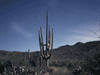
| Four years earlier we had missed the turnoff to our first stop and I was determined not to miss it again. Finally we found the turnoff and within a few minutes arrived at Desert View Tower. Desert View Tower has been a popular stop for almost 100 years as a place to stop and rest and cool off after leaving the desert or before entering it. The tower isn't tall, only about four stories (60 feet), but it's location at the edge of the mountains allows it a view all the way to Arizona. The ground floor is mostly a gift shop with some very nice and unique objects. Two floors of the tower make up a museum, and the fourth floor is an observation level with a telescope and views that extend for miles. The third floor includes a door to no-where, rumored to be for UFO docking. Back in the days when I-80 still ran through here, this was a popular tourist stop along that highway. Because the canyon is so narrow, the old road had to be sacrificed at this location to make room for the new highway. Pieces of the old road survive between the man-made canyons cut for the new roadway. Today, the tower is beside the new highway, but a mile or so from the off-ramp on a parallel road, and it is the last road-side attraction between San Diego and Phoenix. |
| The tower isn't the only attraction at Desert View Tower, two others amused us. We enjoyed climbing through, around, over, and under a garden of natural and artist made rock carvings. A dozen or more animals and characters were carved in the stone by Merle Ratcliff during the depression, many accented with color paint. Large rocks have fallen over the years forming tunnels and caves. Once we had finished with this granite zoo, we continued to the trail to the springs. My wife decided to stay below but I marched up the trail to the springs. We had been informed before starting out that the hike was better than the springs, but I enjoyed seeing the springs as well. We bid fair well to the tower and continued east on I-8. |
| We had stopped to see the Plank Road four years earlier so we drove on by, but now that I know what it looks like, I realize you can see it from I-8 in a fenced off area to the right amid the dunes. We passed Felicity, a stop I though we might make on the way home. We exited at Winterhaven and stopped for a minute at Saint Thomas Indian Mission on the site of old Fort Yuma and Mission La Purisima Conception before that. We drove across the Ocean to Ocean Bridge, a one-lane ribbon that once carried Highway 80 over the Colorado River to tie together the opposite sides of the county. Today it connects Yuma to Winterhaven. We got back on the highway for a few miles and exited at Avenue 3E, going south to County 15th Street west. A few miles west and we came to E1 south and then to Saihati Camel Farm. |
| More than just camels, there are several dozen species of exotic and not so exotic animals bread at Saihati Camel Farm and supplied to petting zoos and the like. I think I liked best the Patagonian Cavy which are large Gianni Pigs that look more like large rabbits. There is food available to feed the goats, but for most of the other animals, it is best to keep a safe distance. |
| On the way in, we had noticed a sign for The Peanut Patch and decided to check it out on the way back. The Peanut Patch isn't anything exotic, just a store with fresh fudge, peanut and nut related items of all sorts, and tours on certain days - this wasn't one of them. We bought a pound and a half of fudge because as the sign said, "A balanced diet is chocolate in both hands." |
| I realized that the tank of gas we bought in Los Angeles was almost gone and was pleased to have gotten this far. We got gas and checked into our hotel and enjoyed a Valentines Day dinner at Mimi's. |
| Day Two |
| We got up early and had breakfast. My wife hadn't slept well so she stayed in the room and rested and did homework while I saw a few sites by myself. |
| First I attended Mass at Saint Thomas Indian Mission which is on the former site on an old Spanish Mission and later Fort Yuma. The priest always preaches up a storm, then ends it with a corny joke. The church which had been built in 1922 had changed since my previous visit. A new entry and rest rooms had been added to the front. |
| At the base of the hill where the mission sits, beside the railroad, is what I originally thought was an old railroad depot. A few hours later I discovered it was the California Port of Entry along old Highway 80. Regardless, the building should be repaired and preserved for its historical significance, but there isn't enough money and interest. So it sits structurally sound, but in very sad shape. I took a few photos and continued. |
| I took a few photos of a canal and drove back over the Ocean to Ocean Bridge into Yuma. I drove around the historic area a little looking for historic buildings, of which there are many in Yuma, and then to Yuma Territorial Prison State Historic Park. I had visited the prison four years earlier, but most of my camera equipment had been stolen the week before including my flash. Today I got some better photos although I was told the volunteer guide has moved away. Does anyone in Yuma want the volunteer guide job? The prison was built in 1876 and housed 3,069 prisoners during its thirty-three years of operation. Later the town used it as a school. The prison had electricity and air conditioning before most of the town and the townspeople called it the hotel. I toured the cells and the exercise yard and especially the Dark Cell where the extra naughty prisoners were sent. The former kitchen building is now the museum with some exhibits and a video. A model shows what the facility looked like when in use. The first time we visited, there was a gun fight drama later in the day and I assume it still is, but I moved on to my next stop before then. Part of the prison was demolished to make way for the current railroad right-of-way and bridge and several trains passed by while I was there. |
| From the prison, I could see a park beside the river so next I drove the short distance to Gateway Park which is along the Arizona side of the Colorado River in the area under the Ocean to Ocean and the railroad bridges. I wandered for some time, photographing the bridges, the bridges with trains crossing, the river, railroad equipment, other equipment, a locomotive that looked ready to display somewhere but didn't have a somewhere yet. I drove a few blocks to the loading area for the Yuma Valley Railroad which we missed four years ago, but sadly the track needs eighty million dollars of repair before it can be used again by which time the train will need repair. Anyone got $80,000,000.00 they don't need? There is a lot of history around Yuma and I drove by several sites on my way back to the hotel where my wife was resting and doing her homework. |
| We now headed north on California Highway S24 through Bard toward Imperial Dam. The highway zig-zags as it works its way north through agricultural lands. We tried to stop at Sun Garden Growers but it was closed (again). |
| Four years earlier we had driven by the Cloud Museum but didn't have time to stop. Today it was a planned stop and we very much enjoyed wandering through several acres and buildings of over 100 old cars, trucks, equipment, tractors, parts, gas pumps, wheels, windmills, housewares, and junk. Must of the cars are rusting hulks that the owner told me aren't worth much unrestored and cost more than they are worth to restore. Still, several are restored and we were glad we had time to stop this time. It is in Bard on Highway S24, open most days for $5.00 a head. |
| We stopped at Imperial Date Gardens where people were lined up to buy date shakes. There were also a variety of dried fruit and trinkets available. |
| I wanted a few more photos of the road side marker for Mission San Pedro y San Peblo de Bicuner. Nothing visible remains of this short lived mission and even the location is disputed by some. It is only a short distance from the river and may have been on the hll behind the marker. The Padres weren't too good to the natives and the natives attacked both missions one night and that was the end of the Missions of the Colorado River near Yuma. |
| We crossed over the Colorado River and continued into Arizona. The road passes through Yuma Proving Ground, a military base, but the main base is a large fenced area to the north with unfenced training areas to the south. There is a Cobra gunship on a pedestal by one entrance to the fenced area and two large pieces of artillery where this road meets Highway 95, and between is Wahner E. Brooks, a large display of mostly World War II and Korea era military equipment. I don't know if this display is new, but I don't remember driving past without stopping four years ago. My wife rested in the car as I wandered around photographing both the equipment and some scenery. |
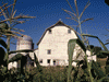
| We got back into town in time for one last stop, Casa de Coronado Museum at Best Western Coronado, the oldest Best Western in the US and first motel in Arizona. The museum is in the house/office where the owners originally lived and is shown by appointment. The manager was busy with an emergency when we tried to visit earlier in the afternoon but now she was free. We enjoyed this small museum which was both a historical house filled with old housewares, and also artifacts from the early days of motels. The motel owner also runs First Flight at Yuma Landing a restaurant that celebrates the first aircraft landing in Arizona here in Yuma. There is a lot of history in this forgotten corner of Arizona. |
| We went to a famous local establishment for dinner. Lutes Casino is a local favorite with pool, arcade games, and old men playing dominos. It is also famous for potato tacos which are rolled tacos like a taquito, except filled with potato, topped with shredded cabbage and cheese. The decor was whimsical eclectic with deer heads from the ceiling, a large fish with a man inside, and other unusual subjects. It is on Main Street in the heart of Old Town. |
| Day Three |
| I awoke to the sound of my wife vomiting and it was afternoon before she felt better. We got a little later start than we had hoped, but were heading west back into California. We stopped at Felicity - The Center of the World, but they only allow visitors to tour the site with a guide and it was much too early for that. I photographed the Granite Wall of History, pyramid, and chapel from the parking lot and we continued west. We turned north onto S34, Ogilby Road, which allows seeing the scenery at a slower pace. The desert scenery was beautiful but the overcast sky made for muted colors as we drove north to meet Highway 78 west. |
| This is a desolate area and we drove some time looking for a restroom. We stopped a few minutes at Hugh Osborn Scenic Overlook in the middle of Imperial Sand Dunes, AKA Algodones Dunes. It wasn't as windy as four years ago, but just as filled with off road vehicles. We continued to Brawley where we caught Highway 111 north. We finally found a rest area near Ramer Lake and then continued to our next stop. |
| There are no signs to our next destination and we almost missed the turn at Schrimpf Road, a dirt agricultural road between two fields. We drove about five miles west to Davis Road and there, on the northeast corner, we found the Imperial Mud Pots. There are no signs, parking areas, or services, just a few acres of cones of what some describe as mud volcanos. My wife rested in the car as I wondered the site for about an hour. Some pots just bubbled, some plopped out globs of mud. Some were pools and some were cones. The closest pot was about one hundred feet from the road, yet, we could hear them from the car. I don't understand why they aren't better known but I was fascinated by them for as long as we had time. |
| Back on Highway 111, we continued north to turn right at Main Street in the town of Niland, an agricultural town that has seen more prosperous days. An old, disused, packing plant looked to have been built with pride and style. It was only a few miles to a very large example of folk art, Salvation Mountain. There are no facilities, admission charge, or information, just a mountain of hay bails, adobe, and poles covered with thousands of gallons of paint in all colors. Everywhere the artist has written such inspirational phrases as, "God is love." Slab City, a place where snow birds spend the summer in campers and trailers, is close by. We wondered an hour and headed back to the highway. |
| I stopped a time or two to photograph the Salton Sea, a large salt water lake formed when an aqueduct broke almost a hundred years ago and everyone decided to keep it. Two trains filled with concrete railroad ties stretched out along the other side of the road. Had the Yuma Valley Railroad been built with these ties, it would still be running. |
| Eventually we reached I-10 and headed west. We hit some traffic and made one last stop. |
| I've several times tried to photograph the dinosaurs at Cabazon, once at night, once from a moving bus, now it was raining as it had been since we left the Salton Sea. It had changed. For many years, two concrete dinosaurs had stood on this spot, waiting for the others that never came after the sculpture died just before completing the second figure. Today, although closed, a new dinosaur park had been added. Information was sketchy and I'm not even sure what it's called, but several fiberglass dinosaurs, like the ones we saw six weeks ago in Texas, could be seen towering above the fence in the heavy rain. |
| We got back into traffic and continued west. The rains cleared around Pasadena and we arrived home a bit before dark. We still had a little of the gas we bought in Yuma. Two of our cats missed us and greeted us at the door, the youngest required a hug before she remembers us, then she too was all over us. We drove about 750 miles, saw mostly new sites in Yuma, learned a little more history, and missed most of the rain. We may return some day, especially if they reopen the Yuma Valley Railroad. There are still a few things to see next time. |

|

|

|
| Note:This is not the official site for any of the places shown in Places Earth. Places Earth is not responsible for accuracy of the information. Hours of operations, prices, exhibits, and sometimes locations are subject to change without notice. |
|
Support this Web Site I hope that you find this web site helpful. It started because of my love for Architecture and interest in History and a desire to share my photographs and tales of my adventures. I don't allow paid advertising. This web site is for your benefit and enjoyment and I make no profit on it. For twenty years it has been supported primarily from my regular paycheck as a Set Designer. If you are in the need of a designer, please see my Set Designer portfolio site Set Design Portfolio. |
|
Links |

|
This site maintained by Kenneth A. Larson. Copyright © 2004 - 2023, Kenneth A. Larson. All Rights Reserved. Website content including photographic and graphic images may not be redistributed for use on another website. |

|

|

|