Places, Earth
Eastern Sierras - The Loose Ends Trip
Eastern Sierras - The Loose Ends Trip
|
|
Places, Earth
Eastern Sierras - The Loose Ends Trip |
|
| Day One |
| Two years earlier, we had gone to Death Valley for Easter, but couldn't see the Charcoal Kilns because they are at high elevation and the road was closed due to snow. Two months later, we drove up Highway 395 east of the Sierras and couldn't see Devil's Postpile because of snow and in the same trip, continued on to Nevada because the passes through the Sierra Nevada Mountains were closed due to snow. We also missed the Mill tour at Bodie because of a schedule conflict. The following year, we visited Yosemite at Easter and couldn't visit Glacier Point because of, you guessed it, snow. When I realized that this Fourth of July weekend would be a three-day weekend, I began planning this catchup trip to see all these things that we had missed previously. Then to avoid paying holiday pay, my employer gave us a whole week off, so we made it four days. |
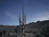
| So, about 7:30 on July 4 (an hour behind schedule as always), we headed north from Los Angeles on Highway 14 to the turn off to Ridgecrest at Highway 178. We passed through Inyokern, past Naval Air Weapons Station China Lake, through Ridgecrest where the Maturango Museum was closed for the holiday, and through Searles Valley and the forgotten communities around Trona. I had hopes of making a quick stop at Trona Pinnacles for a few updated photos, but was disappointed to see the entire scene was obscured by haze (later I was told it was from brush fires some distance off) so we pushed on through to Inyo County. |
| It took about another half hour before we began the descent into Panamint Valley. We passed the ghost town of Ballarat which we had seen two years earlier and went straight at the turnoff to Panamint Valley Road and began climbing up into Wildrose Canyon, entering Death Valley National Park. As the map had shown, about ten miles along, the road turned rough for about four miles until we intersected with Immigrant Canyon Road. We turned right and the road was good for a few more miles, then got very rough for the last four. I guessed that we were close when I noticed my car overheating for the first time in its 128,000 miles. It was hot, but not vary hot and there was a bit of a breeze while we waited for the engine to cool, but I guess the thin air and steep grade got to be too much for the old car. I flagged down a car coming back from the Charcoal Kilns and was told I was almost there and to keep going. It wasn't until later that I realized that the bit of rock I saw between the trees at a curve in the road a thousand feet ahead |
 The kilns were just around the bend.  Waiting for the engine to cool. |
| was one of the ovens. Had I known, I would have walked the rest of the way while the engine cooled. | |
| Anyway, after about fifteen minutes and a little added water later, we pushed on the last short distance to the kilns. There was something intriguing about these 10 beehive shaped structures about 30 feet in diameter and 30 feet high in a neat row a few hundred feet long beside the road. They all had a small doorway on the side that faced the road and most had an opening high on the other side. There were also numerous small square holes around the base. On the inside, some still smelled of pine pitch |
 We almost canceled the trip because my wife hadn't finished her homework, but she was all done by the time we got home. |
| and they provided a vivid echo. Beside the first kiln, a trail head begins that runs several miles up the mountain and, I am informed, provides an incredible view of Death Valley far below. We stayed about an hour and headed back to the intersection but this time, continued straight along Immigrant Canyon Road for a scenic drive until, a little passed the turnoff to Skidoo Ghost Town, we met Highway 190. Highway 190 is one of the main roads into Death Valley, but we now took it back out, going around Owans Lake on the northeast, |
 Owans Lake. |
| and eventually reaching the Lone Pine Visitor Center at the intersection of Highway 395 and 136. | |
 Lone Pine Visitor Center interior recently opened. | We had stopped at the Lone Pine Visitor Center two years earlier when it was newly completed, today it was all moved in and we got some updated information on the area. One point of interest was the Lone Pine Film Museum which opened shortly after our previous visit and that, is where we went next. When we pulled in, there was only one car and the museum looked closed. I shot some photos of the exterior and we were about to move on when the door opened and we were invited inside. Lone Pine have been long been a location for motion picture, TV, |
| commercials, and still shoots. The Alabama Hills on the west edge of town were used since silent screen days in countless westerns as well as films set in India, science fiction films, and other film genres. The museum had a lobby filled with items, including a stage coach. To one side is a theater showing an informative film and beyond the lobby, a large space was filled with more memorabilia including several cars. A small exhibit area was devoted to the movie Tremors and another to the recent Ironman. We spend about an hour here and pressed on. |
 Lone Pine Film Museum. |
| We made a quick stop in the town of Independence with its classical Courthouse which was being set up for the Independence Day festivities for that evening. I also stopped for a few minutes at Eastern California Museum because I wasn't satisfied with the photo I took of the coyote dentures two years earlier. The Eastern California Museum is, in my opinion, one of the best small town museums I've seen and I was impressed to see it had been rearranged and had new exhibits. Oh, the coyote dentures? They were home made by a man using tooth brush handles and coyote teeth and are one of the most popular exhibits at the museum. We only had time for this quick reshoot and the museum officially closed a few minutes before I got there, so we moved on. |
| We stopped for gas in Big Pine and continued. A bit north of Big Pine are four large antenna dishes. They look like satellite or space craft tracking antennas, but I don't know for sure. We finally reached our accommodations for the first two nights in Bishop, probably the largest town in the area. We settled in and my wife worked on homework for a class she had just finished, but somehow the homework got lost in e-mail. About 9:00 we drove about two blocks and found the spot where everyone was gathering to watch the |
 Fireworks in Bishop. |
| Bishop Fire Department Fireworks Display at the Bishop Airport. It was a bit of an obstacle course driving between all the amateur firework displays in the street, but we found a spot. Finally the fireworks display started and we were a bit disappointed. Everything was low and we could barely see it so we started to leave. Then it got better and we quickly pulled over and stayed to the end. Back in the room, we got off to sleep. | |
| Day Two - Ghost Towns and Brine Flies. |
| We hadn't left a wake-up call and overslept - 7:00. We got off later than planned and had to hurry north through the beautiful scenery of the east side of the Sierra Nevada Mountains, past Crawly Lake, saw some real cowboys on horseback herding cattle just beyond the other side of the highway, drove through tall pine tree forests, and paused a few times to photograph Mono Lake. At Bodie Road, we turned right and headed east up a narrow canyon about 20 miles to Bodie State Historic Park. |
| Two years earlier, we arrived in Bodie at 8:00 am and it was quiet, today it was almost 11:30 and quickly filling with visitors. I dropped my wife off to get the Mill Tour tickets and headed for the parking lot. I paused to photograph a building from the car and was passed by a car which got the last parking space. I had to park on the road further on. I found my wife and we looked around a bit before the tour. Waterman S. Body (AKA William S. Bodey) and his partner discovered gold in Bodie (note that when the town was chartered, Body was changed to Bodie) in 1859. In 1879, Bodie had a population of 10,000, by the time it became a state park in 1962, only a few people remained. Since we had seen most of Bodie two years earlier | |
 Looking at Bodie from the Cemetery. |
 A path in Bodie. |
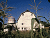
| when it was cooler and less crowded, we were mostly interested in the Mill Tour. Our guide, Dave, first showed us the back side of the mill with the track overhead for ore cars, explained a bit about ore crushing, and showed us tons (literally) of old equipment and explained their uses. Dave also explained about the railroad built to bring in fire wood for the steam boilers that ran the equipment and how the water used for the steam was ground water that needed to be pumped out of the mine anyway. Town water came from a spring several miles away that still serves Bodie. Dave also discussed the difficulty of hauling these tons of equipment by mule or horse from Carson City and San Francisco. Then we went inside the mill where we saw the machine shop with the largest drop center machine lathe in the west and early electrical equipment that made the mill profitable again as gold and silver production slowed. We saw the stamps that crushed the ore into small pieces and Dave explained the various ways that gold was extracted from ore using a variety of mechanical and chemical processes. We also learned about mill safety and how the mill cared for injured employees. In short, little attention was paid to safety and nothing was paid to injured employees, they we given the boot. Once the tour was over, we headed back to the car, with me stopping a bit at the cemetery which we had missed the previous time. As we drove out the gate, I remembered two years ago while in Bodie, we heard sirens and right at the gate, saw a car with a head size hole in the passenger side windshield. We double checked our seatbelts and prayed for safe travels. | |
 Exterior of Mill. |
 Interior of Mill. |
| We had been in too much of a hurry to get to Bodie in the morning to stop at Mono Lake, but now we had a little time and made several stops at the lake. At Old Harbor, I was photographing the brine flies and sea gulls when a man in a kayak pulled up and asked for my assistance in helping him land his craft. It turned out he was giving a lecture that evening at the Visitor Center on "Birding from Kayak." He had a long camera lens that simply made me jealous. We did stop at the Mono Basin Scenic Area Visitor Center, but had to leave |
 West shore of Mono Lake. |
| long before the lecture as we were trying to get to Devil's Postpile. I made a quick stop at the Mono Lake Committee Visitor Center and Book Store. I've been a member for many years, but never saw the building before. We continued south on Highway395 admiring more scenery. | |
| We turned right at Mammoth Lakes Scenic Loop through a beautiful pine forest and turned right at Highway 203 west. I made a quick stop at Earthquake Fault, a rift in the earth so deep that the ice at the bottom never melts. The entire region is seismically active and a few years back, geologists were predicting a possible major volcanic event. It never happened but eventually will. The large volcano in the middle of Mono Lake is only 300 years old, young in mountain years. A popular warm springs in the area is no longer open to the public because it is dangerously hot. Don't put off a visit too long, it may no be here. We continued on and as we rounded a bend, I thought some Sci-fi movie was shooting a spacecraft scene, but it turned out to be the aerodynamic shape of a lower station of a ski lift. When we got to Mammoth resort, we were disappointed that the mandatory shuttle to Devil's Postpile was | |
| sold out for the day. The last shuttle leaves at 7:30, and it was only 4:30. There was a aerial tram taking people to the top of the mountain, I assume for the view, but we were now too discouraged to take it. We photographed a large, life-size, bronze mammoth to send to my friends at the Page Museum (La Brea Tar Pits) and turned around. The Mammoth Lakes Visitor Center closed only a few minutes before we got there so we headed back to Bishop, stopping quite often to photograph the spectacular scenery. |
 Tickets to Devil's Postpile were sold out. |
| Back in Bishop, I bought some antifreeze since my car was still complaining of low coolant levels and retreated to our room for the night. I worked on my photos and this article while my wife did more homework. |
| Day Three - Laws and Disorder |
| We awoke, had breakfast, and attended Mass at Our Lady of Perpetual Help Church in Bishop with a view of the Sierra Nevada Mountains out the window behind the altar. After returning to our room to pack and check out, we headed north on Highway 6. |
| It only took about ten minutes to reach the small town of Laws, once a major railroad center. Just as I was saying to my wife, "I wonder where I turn," I saw the sign that said, "Turn right here." A minute later I pulled into the parking lot across the road from Laws Railroad and Historical Museum. We paid our $5.00 donation, signed in, and began a casual stroll through eleven acres of railroad cars, locomotives, related buildings, and equipment as well as dozens of other buildings containing all sorts of antiques, displays, and exhibits. Some of the buildings, particularly those related to the railroad, are on their original sites, Others have been moved here from the area, and a few are reproductions sometimes from materials savaged from older buildings. Each building is devoted to a subject. One building had printing equipment, one had collections of bottles, one is a black smith shop, another housed fire engines. Another visitor was from the area and said both of her children were born in the doctor's office which was now filled with several medical related exhibits. Several houses were set up as homes and the school was, well, you guess. We wandered a bit over two hours, bought a few old Christmas decorations from the Trading Post, and got into the car and turned the key. |
 The north end of Law's Railroad Museum and Historic Site. |
 Train at Law's Railroad Museum and Historic Site. |
| An hour later, an AAA roadside assistant pulled up and tried to get my car started. Of course, when he arrived, it started, then we tried again and it didn't. Then we tried with and without a jump and it started. We suspected the starter was starting to go bad and there was no one in Bishop that Sunday who could fix it. We had motel reservations in Mariposa and figured we could get there on a tank of gas but couldn't get home on what we had. We decided that if was stopped for gas and couldn't restart the engine, we would rather be where we had a room reservation, so we thanked AAA and headed back to Highway 395 north. |
| We retraced our path from the day before as far as Highway 120 near Lee Vining. We had hoped to stop at Mono Lake South Tufa to see if anything had changed from our visit two years earlier, but didn't want to stop the car. So we headed west on Highway 120 into the Tioga Pass, stopped a few minutes at Ellery Lake (a MWD reservoir), and entered Tuolumne County and Yosemite National Park. I had been this way many years earlier with my Father, but couldn't remember much and my wife had never seen this part of Yosemite National Park. The car strained to make it over the 9945 foot high pass and then mostly coasted down the other side through beautiful views of lakes and trees and the other side of the rocks and mountains that make the north side of Yosemite Valley. We were afraid to stop at Tuolumne Meadows and crossed into Mariposa County, still in the park. Tenaya Lake was beautiful and Olmsted Point was breathtaking and the weather was noticeably cooler which was welcome since we were trying not to use the air conditioner. Highway 120 twisted between Tuolumne and Mariposa Counties as it wound its way west through the Sierras. We were getting a bit tired of the curves by the time we stopped at Merced Canyon Overlook and finally reached the floor of Yosemite Valley. |
 Tuolumne Meadow. |
 Rock surface scratched by claciers thousands of years ago at Olmsted Point. |
| We got as far as the Yosemite Chapel before we tuned around and headed out, this time on Highway 140 to Mariposa. We had a slight detour about half way crossing to the other side of the river and back again and as I looked across the river to the main road, I was shocked to see several hundred feet of road buried under a landslide. We arrived in Mariposa, a former mining towen, about 7:00. We had planned to stay at the Best Western but somehow I dialed the wrong number when I made the reservations and ended up in |
 Mariposa Gazette in Mariposa. |
| another motel which we didn't care for, so we were glad it was only for one night. We did enjoy a wonderful diner at Miner's Inn Restaurant, part of another motel in town. Having cut several stops from our plans, we had arrived in Mariposa early and had a more leisurely evening than is usual for us while traveling. | |
| Day Four - Will We Make It Home Today? |
| We awoke early hoping our car would start. We ate our continental breakfast and walked across the street to the Visitor Center for some local information in case we spent the day fixing the car. I also asked about that rock slide across the highway we saw the day before. It seems the worst of it occurred about April 2006, but had been slipping for a while and no one was on the road at the time. It sounds like the detour will become a permanent realignment of the highway. We returned to our room, packed and load the car, and fortunately, the car started just fine and we drove into town. We were relieved when the car started again after getting gas and we drove by the Mariposa County Courthouse (oldest continuously operating west of the Mississippi) and the Mariposa Museum and History Center which wasn't yet open for the day. Mariposa also has another famous museum, California State Mining and Minerals Museum at the fairgrounds. Unfortunately, we had to put all this off till another time if we wanted to finish with Yosemite. |
 Mariposa County Courthouse, oldest continuously operating west of the Mississippi. |
 Mariposa Museum and History Center Mariposa Museum and History Center |
 Bridalveil Fall. |
We headed back to Yosemite along Highway 140 again past that rock slide and finally found Bridalveil Fall which I couldn't find the day before. Because we were afraid to turn off the engine, we took the short walk to the base of the falls in shifts so one of use could watch the car. This was a loose end from the year before when we planned to stop on the way out but ran out of time. Bridalveil Fall is a year round waterfall unlike some others and is easily reached from the road. We now left Yosemite Valley and headed to Glacier Point which looks down on Yosemite Valley and afforded breathtaking views of Half Dome, the highlands beyond the valley to the north, and the highlands to the south. It also allows a view down to Vernal Fall and Nevada Fall which are otherwise reached by a difficult trail. The year before, we had hiked as far as Vernal, but my wife turned back before we reached Nevada Fall. My wife decided |
| to pass on the view so that we could get on our way sooner and we headed out of the park. As we headed downhill on Highway 41, we suddenly found ourselves in the middle of a small traffic jamb. Since I had to stop anyway and I assumed it was to watch an animal, I looked around to see. Then up the hill, I saw the bear which looked like a juvenile, turning over rocks and debris looking for food. I took a photo and the bear decided it was time to move on, and so we did too. We decided to skip one other loose end, The Mariposa |
 Vernal Fall |
| Grove, because we didn't want to shut off the engine and we were both too tired for a long hike in such hot weather. | |
| We continued on highway 41 through Oakhurst, which is the southern end of Highway 49 and the Gold Country, and on to Fresno where we caught Highway 99 south. Fortunately, the car started after getting gas in Bakersfield and we continued on our way. Per tradition, we played Sons of the San Joaquin as we climbed the Grapevine out of the San Joaquin Valley and an hour later arrived home. We covered a lot of ground, tied up several loose ends, didn't see Devil's Postpile or the Mariposa Grove, and wanted to spend more time at Mono Lake, but otherwise accomplished most of our goals. We discovered several new things to visit when we try again which will be in a few years. |

|

|

|
| Note:This is not the official site for any of the places shown in Places Earth. Places Earth is not responsible for accuracy of the information. Hours of operations, prices, exhibits, and sometimes locations are subject to change without notice. |
|
Support this Web Site I hope that you find this web site helpful. It started because of my love for Architecture and interest in History and a desire to share my photographs and tales of my adventures. I don't allow paid advertising. This web site is for your benefit and enjoyment and I make no profit on it. For twenty years it has been supported primarily from my regular paycheck as a Set Designer. If you are in the need of a designer, please see my Set Designer portfolio site Set Design Portfolio. |
|
Links |

|
This site maintained by Kenneth A. Larson. Copyright © 2004 - 2023, Kenneth A. Larson. All Rights Reserved. Website content including photographic and graphic images may not be redistributed for use on another website. |

|

|

|